Offline Guide
Alaska or Bust
North Georgia → Pacific Northwest → Alaska Cruise → North Georgia
Find your way
Contents
Before you go
The stops · Outbound
The stops · Return
Trip overview
Total round-trip distance
Approx. 8,000–9,500 miles
Drive days outbound
10–12 days (suggested)
Drive days return
12–13 days (suggested)
Full trip with cruise
4–5 weeks total
Cruise ports
Seattle, WA or Vancouver, BC
Daily driving sweet spot
300–400 miles / 5–6 hours max
America the Beautiful Pass
$80 — buy at your first national park. Covers all 14 parks on this route.
Mile-by-mile drive legs
Outbound · Southern Route
- North Georgia (Blairsville area) to Chattanooga, TN90mi · 2h
- Chattanooga, TN to Nashville, TN135mi · 2h
- Nashville, TN to Memphis, TN210mi · 3h
- Memphis, TN to Oklahoma City, OK470mi · 6h 45m
- Oklahoma City, OK to Amarillo, TX265mi · 3h 45m
- Amarillo, TX to Albuquerque, NM285mi · 4h
- Albuquerque, NM to Santa Fe, NM65mi · 1h
- Santa Fe, NM to Petrified Forest, AZ245mi · 3h 30m
- Petrified Forest, AZ to Sedona, AZ120mi · 2h
- Sedona, AZ to Grand Canyon South Rim, AZ115mi · 2h
- Grand Canyon, AZ to Joshua Tree, CA375mi · 5h 30m
- Joshua Tree, CA to Big Sur, CA385mi · 6h
- Big Sur, CA to Crater Lake, OR490mi · 7h 30m
- Crater Lake, OR to Mount Rainier, WA410mi · 6h
- Mount Rainier, WA to Seattle, WA / Vancouver, BC90mi · 2h
Return · Northern Route
- Seattle, WA to Olympic National Park, WA110mi · 2h
- Olympic NP, WA to Columbia River Gorge, OR210mi · 3h 30m
- Columbia River Gorge to Missoula, MT440mi · 6h 30m
- Missoula, MT to Glacier National Park, MT130mi · 2h
- Glacier NP, MT to Theodore Roosevelt NP, ND435mi · 6h
- Theodore Roosevelt NP, ND to Badlands, SD225mi · 3h
- Badlands, SD to Mount Rushmore, SD85mi · 1h 30m
- Mount Rushmore, SD to Minneapolis, MN580mi · 8h
- Minneapolis, MN to Boundary Waters, MN165mi · 2h 30m
- Boundary Waters, MN to Mackinac Island, MI490mi · 7h
- Mackinac Island, MI to Niagara Falls, NY450mi · 6h 30m
- Niagara Falls, NY to Finger Lakes, NY100mi · 1h 30m
- Finger Lakes, NY to Shenandoah, VA370mi · 5h 30m
- Shenandoah, VA to North Georgia615mi · 8h 30m
Suggested itinerary
Outbound, 12 days
- 1
Into Tennessee · 245mi
Chattanooga (Ruby Falls, Aquarium) · Nashville (arrive evening)
- 2
Music City & the Blues · 210mi
Nashville morning (Ryman, Hall of Fame) · Memphis afternoon + evening (Sun Studio, Beale Street)
- 3
Memphis to the Plains · 470mi
Civil Rights Museum — start early · Oklahoma City Memorial (late afternoon)
- 4
Texas & New Mexico · 550mi
Cadillac Ranch (quick stop, AZ-40 westbound) · Palo Duro Canyon (25 min south) · Arrive Albuquerque evening
- 5
New Mexico Day · 130mi
Santa Fe full day · Georgia O'Keeffe Museum, Canyon Road, dinner
- 6
Into Arizona · 365mi
Petrified Forest / Painted Desert (midday stop) · Sedona (Chapel of the Holy Cross at sunset)
- 7
The Canyon · 115mi
Grand Canyon arrival (afternoon) · Rim sunset · Stay on rim — Bright Angel or El Tovar
- 8
Grand Canyon to the Desert · 375mi
Grand Canyon sunrise — Mather Point · Drive to Joshua Tree · Cholla Cactus Garden at sunset
- 9
Coast & Big Sur · 385mi
Pacific Coast Highway · Bixby Bridge · Dinner at Nepenthe
- 10
Oregon Bound · 490mi
US-101 north through redwoods · Crater Lake evening arrival or morning
- 11
Crater Lake & Rainier · 410mi
Crater Lake Rim Drive (morning) · Mount Rainier arrival (late afternoon)
- 12
To the Ship · 90mi
Paradise meadows if arriving day before cruise · Seattle or Vancouver — your adventure begins
Return, 13 days
- 1
Olympic Peninsula · 110mi
Hoh Rain Forest Hall of Mosses · Ruby Beach
- 2
The Gorge · 210mi
Columbia River Gorge Historic Highway · Multnomah Falls · Crown Point
- 3
Into Montana · 440mi
Driving day — the landscape transforms · Arrive Missoula evening
- 4
Crown of the Continent · 130mi
Going-to-the-Sun Road (full day) · Logan Pass · Stay in Whitefish or East Glacier
- 5
Big Sky → Badlands · 435mi
Theodore Roosevelt NP (late afternoon Scenic Loop) · Medora for the night
- 6
The West That Was · 310mi
Badlands Loop Road · Wall Drug · Mount Rushmore evening ceremony
- 7
Great Lakes · 580mi
Long drive day — leave at 6am · Arrive Minneapolis evening
- 8
Boundary Waters & North · 330mi
Boundary Waters day paddle from Ely · Return to Duluth or Two Harbors
- 9
Michigan & the Island · 450mi
Upper Peninsula scenic drive · Mackinac Island ferry + afternoon
- 10
Great Falls · 450mi
Drive through Detroit · Niagara Falls evening + Maid of the Mist next morning
- 11
Finger Lakes · 100mi
Watkins Glen gorge trail · Winery visits · Ithaca dinner
- 12
Shenandoah · 370mi
I-81 S through the Valley · Skyline Drive · Big Meadows elk at dusk
- 13
Home · 615mi
Leave early · Break in Chattanooga or Wytheville · Home
Things worth knowing
💛 The America the Beautiful Pass — Buy This First
- $80 at any national park entrance gate. Covers the driver and all passengers in one vehicle.
- The Grand Canyon entry alone is $35. You'll recoup the pass cost at your second park. After that, every park on this route is free.
- Buy it at your very first national park (the Petrified Forest works perfectly) and keep it in the glove box.
🏔️ Altitude — Something Most Southerners Don't Expect
- Santa Fe sits at 7,000 feet. The Grand Canyon rim is 7,000 feet. Going-to-the-Sun Road at Glacier peaks at 6,646 feet.
- At altitude you may feel more tired than expected, get a headache, or feel short of breath — especially the first day.
- The fix: drink more water than usual, slow down on any walking, and rest if something feels off. It passes quickly.
⛽ Gas in the West — Fill Up Early
- Through the desert Southwest and across Montana and the Dakotas, gas stations can be 50–70 miles apart.
- Rule: any time the tank drops below half in a rural area, stop and fill it.
- Big Sur: no gas for 90 miles between Carmel and San Simeon. Fill completely in Carmel before heading south. This strands people every summer.
🛂 Passports & Cash
- Passports required if departing from Vancouver, BC, or visiting the Canadian side of Niagara Falls (the better view — worth the crossing).
- Keep $150–200 in small bills in the car. Roadside stands, Navajo Nation vendors, some rural parks, and small diners are cash only.
📅 What to Book Ahead
- Grand Canyon lodging (Bright Angel Lodge, El Tovar): 12 months in advance. Not a figure of speech.
- Glacier — Going-to-the-Sun Road vehicle reservations: required May–September. Book at recreation.gov the moment your dates are set.
- Crater Lake Lodge: 6+ months out for summer.
- Mackinac Island Grand Hotel: fills well in advance for summer and fall weekends.
- Albuquerque Balloon Fiesta (first two weeks of October): every hotel within 60 miles books out 6+ months ahead.
- Everything else: 2–4 weeks ahead is typically fine.
✨ How to Make It Extraordinary
- Arrive at the Grand Canyon, Crater Lake, and Glacier at sunrise — not noon. This is the single most important piece of advice in this guide.
- Stop whenever something catches your eye. The unplanned moments are the ones people talk about for the rest of their lives.
- Talk to people at every stop — rangers, diner cooks, gas station attendants. They know things no guide does.
- Write one sentence each night in a small notebook: what surprised you, what you ate, what you'll remember. Takes two minutes. You'll reread it for decades.
Emergency & road resources
Emergency (anywhere in US)
911
Roadside assistance (AAA)
1-800-222-4357
Poison Control
1-800-222-1222
WA road conditions
511wa.gov / call 511
OR road conditions
tripcheck.com / call 511
MT road conditions
mdt.mt.gov/travinfo / call 511
SD/ND road conditions
sd511.com or nd511.gov / call 511
AZ road conditions
az511.gov / call 511
CA road conditions
quickmap.dot.ca.gov / call 511
Wildfire & air quality
airnow.gov
National park road status
nps.gov (search park name)
Park reservations
recreation.gov
The Stops
Outbound · Southern Route
Stop 1
Chattanooga, TN
~30 min off I-75
Chattanooga surprises everyone. You expect a mid-size Southern city. You get a dramatic river gorge, a world-class aquarium on the waterfront, and a mountain with a waterfall inside it. The air smells like the Tennessee River. The city is unhurried.
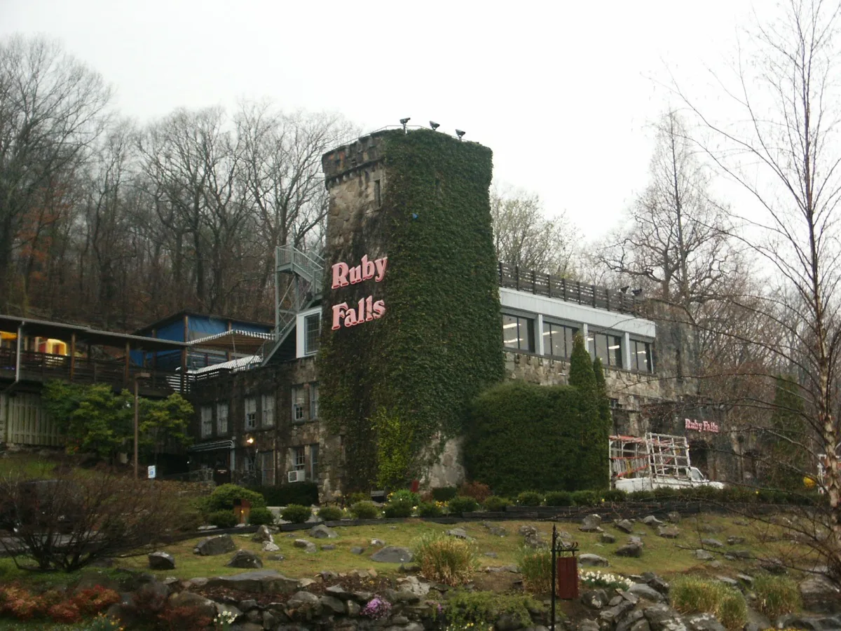
The Tennessee Aquarium is one of the finest freshwater aquariums in the world — two massive buildings tracing a river from mountain headwaters to the open sea. Ruby Falls is a 145-foot waterfall discovered in 1928 inside Lookout Mountain, reached by elevator through solid rock. Both are genuinely extraordinary.
★ The moment
Stepping off the elevator 260 feet underground and walking a lit cavern path until Ruby Falls appears — a 145-foot curtain of water crashing in a cathedral of stone. The sound hits you before the light does.
⚠ Classic mistake
Skipping Ruby Falls because it sounds touristy. It is touristy. It is also one of the most remarkable things in the Southeast. Book tickets online before you leave — lines for walk-ins can be long.
📷 The photograph
Inside Ruby Falls, position yourself on the left side of the viewing area — the falls frame perfectly against the cavern wall from that angle, and the mist catches the light.
⏱ How long do you need?
2 hours: Ruby Falls alone. Half day: Ruby Falls + Aquarium. Full day: add a walk along the Riverwalk and dinner in the Bluff View Art District.
💬 What to ask
Ask your Ruby Falls guide how the cave was discovered. The story of Leo Lambert drilling for a different cave entirely and breaking through to this one is remarkable.
Skip it if
You're in a hard rush to cover miles on day one.
Don’t skip it if
Either of you has never seen a cave waterfall. You haven't.
Entry fee
Ruby Falls: ~$24/adult. Tennessee Aquarium: ~$40/adult.
Gas
Abundant throughout Chattanooga.
Don't miss eating
Banana pudding at Easy Bistro & Bar in the Bluff View Art District — made from scratch, a Southern institution done right. Or the pimento cheese and biscuits at Main Street Meats' deli counter, which does excellent vegetarian sides.
Website
chattanoogafun.com
This season
Spring / Summer
Ruby Falls lines peak in summer — book online and go early. The Bluff View Art District blooms beautifully in April and May.
Summer / Fall
September brings comfortable temperatures and smaller crowds. The gorge walls turn gold by mid-October.
Fall / Winter
Holiday lights along the Riverwalk in December are genuinely lovely. The aquarium has almost no wait times in winter.
Winter / Spring
January is quiet and mild. Ruby Falls is fully climate-controlled underground — weather is irrelevant inside the mountain.
Average weather, all twelve months
| Jan | Feb | Mar | Apr | May | Jun | Jul | Aug | Sep | Oct | Nov | Dec | |
|---|---|---|---|---|---|---|---|---|---|---|---|---|
| High | 48° | 52° | 61° | 71° | 78° | 86° | 89° | 88° | 81° | 71° | 60° | 50° |
| Low | 30° | 33° | 40° | 49° | 57° | 65° | 69° | 68° | 62° | 50° | 40° | 32° |
| Rain | 4.2" | 4.0" | 5.0" | 4.1" | 4.3" | 3.8" | 4.5" | 3.5" | 3.7" | 3.1" | 4.3" | 4.6" |
Other options nearby
Things to do
Tennessee Aquarium
4.7★Aquarium
Waterfront complex with sea & river animals, birds & butterflies, plus interactive shows & cruises.
Chattanooga Zoo
4.4★Zoo
This educational wildlife park houses a large collection of species from around the globe.
Ruby Falls
4.6★Tourist Attraction
An underground waterfall is the main draw of this guided cave tour with gift shops & cafes.
Lookout Mountain Incline Railway
4.4★Tourist Attraction
100+-year-old vertical gauge railway ride to historic sites & a trail with impressive vistas.
Coolidge Park
4.7★Park
Waterfront park with a restored historic carousel, an interactive play fountain & open spaces.
Food & drink
Raising Cane's Chicken Fingers
4.2★Fast Food Restaurant
Fast-food chain specializing in fried chicken fingers, crinkle-cut fries & Texas toast.
Feed Table and Tavern
4.6★American Restaurant
Industrial-style haunt with elevated comfort grub such as grass-fed sloppy joes, plus a lively bar.
Boathouse Rotisserie & Raw Bar
4.6★Seafood Restaurant
Wide variety of seafood & barbecued meats served in a casual bar & grill with an expansive deck.
Golden Corral Buffet & Grill
4.4★Buffet Restaurant
Family-friendly buffet chain featuring all-you-can-eat American fare, plus salad & dessert bars.
Attack of the Tatsu
4.8★Izakaya Restaurant
Stop 2
Nashville, TN
On route — I-24/I-40 corridor
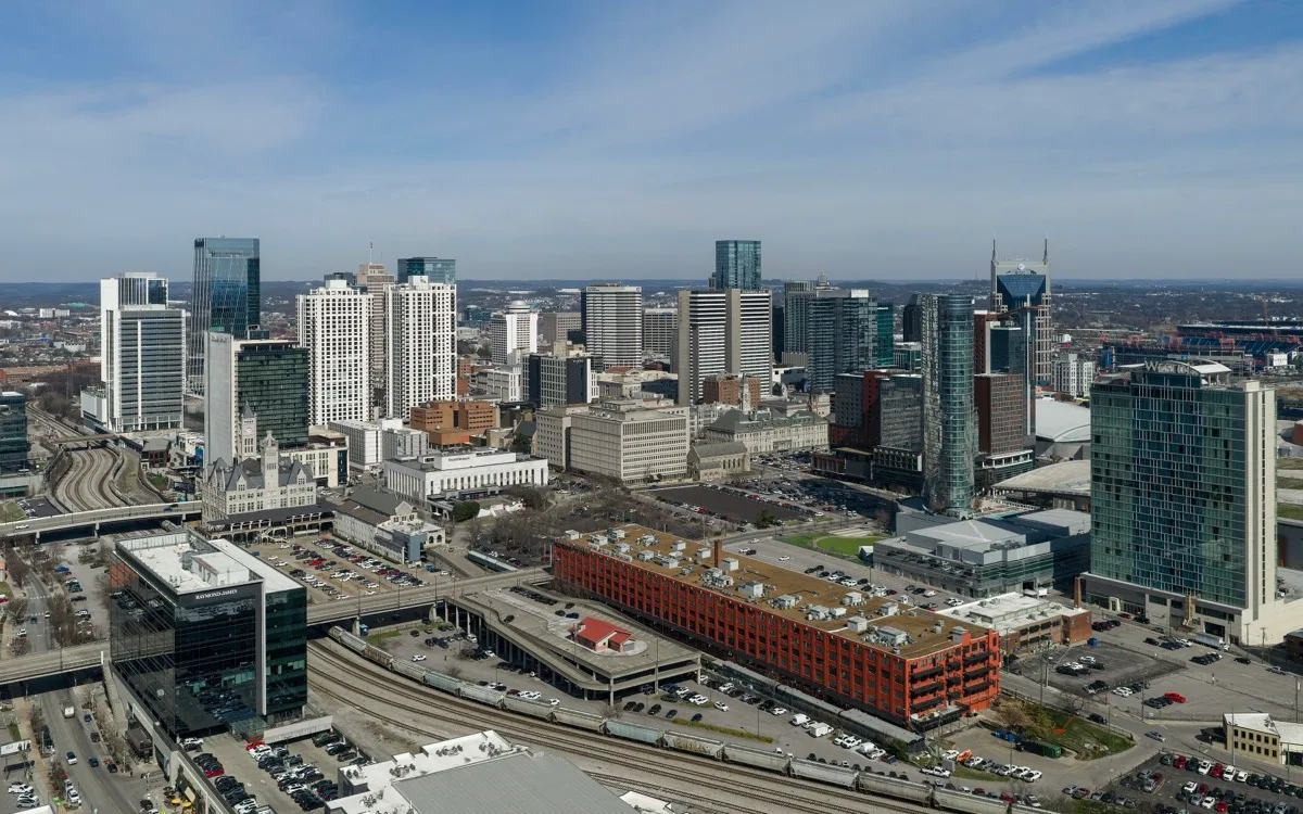
Nashville hits you with sound before anything else. There's live music coming out of every door on Broadway even at noon. The city smells like barbecue smoke and possibility. It's louder and more alive than most people expect, and the food is legitimately world-class.
The Ryman Auditorium is where country music was born — a converted 1892 tabernacle with original wooden pews where Hank Williams, Patsy Cline, and Johnny Cash performed. The Country Music Hall of Fame is one of the great American museums, full of rhinestone suits, handwritten lyrics, and Elvis's gold Cadillac. Neither requires any interest in country music to be moved by.
★ The moment
Sitting in the original wooden pews at the Ryman Auditorium during a self-guided tour, the stage empty and quiet, and understanding why they call it the Mother Church of Country Music. The acoustics are extraordinary even in silence.
⚠ Classic mistake
Spending all your time on Broadway. The honky-tonks are fun for an hour but the real Nashville is the Ryman, the Hall of Fame, and a long dinner somewhere good. Don't let the tourist strip be the whole story.
📷 The photograph
Stand on the Ryman stage during the self-guided tour (they allow it) and photograph back into the auditorium — the arc of original wooden pews curving away from you under the stained glass windows.
⏱ How long do you need?
2 hours: Ryman tour only. Half day: Ryman + Hall of Fame. Full day: add a walk through the Gulch neighborhood and a proper dinner.
💬 What to ask
At the Ryman, ask a staff member which artist's final performance here was the most legendary. The answer changes depending on who you ask and always leads somewhere interesting.
Skip it if
You've been to Nashville before and done the Ryman.
Don’t skip it if
Neither of you has ever walked into the Ryman. That needs to happen.
Entry fee
Ryman self-guided tour: ~$25. Country Music Hall of Fame: ~$27.
Gas
Abundant.
Don't miss eating
The hot honey butter biscuit at Biscuit Love in the Gulch — a Nashville institution, vegetarian, and one of the best things you can eat in the South. Get there before 10am or the wait is real.
Website
visitmusiccity.com
This season
Spring / Summer
Book restaurants in advance — Nashville is booming and waits are real. Centennial Park with the Parthenon replica is beautiful in spring bloom.
Summer / Fall
October brings perfect temperatures. Broadway is much less overwhelming than July. The Nashville Film Festival adds energy.
Fall / Winter
December Broadway is warm with holiday lights and far fewer tourists. A legitimately good time to visit.
Winter / Spring
February is calm and prices drop. A good stop for a long lunch and a walk through the Gulch.
Average weather, all twelve months
| Jan | Feb | Mar | Apr | May | Jun | Jul | Aug | Sep | Oct | Nov | Dec | |
|---|---|---|---|---|---|---|---|---|---|---|---|---|
| High | 48° | 52° | 62° | 72° | 80° | 88° | 92° | 91° | 84° | 73° | 61° | 51° |
| Low | 29° | 32° | 40° | 49° | 58° | 66° | 70° | 69° | 62° | 50° | 39° | 31° |
| Rain | 3.9" | 3.7" | 4.8" | 4.1" | 4.8" | 3.8" | 3.9" | 3.3" | 3.5" | 2.9" | 4.3" | 4.4" |
Other options nearby
Things to do
Grand Ole Opry
4.8★Live Music Venue
Visitors come for daily tours & weekly live radio shows featuring classic & new country acts.
Country Music Hall of Fame and Museum
4.6★Museum
Attraction tells the story of popular American music through artifacts & interactive exhibits.
Nashville Zoo at Grassmere
4.5★Zoo
Multiple habitats housing a global array of animals, plus a popular playground for kids.
The Parthenon
4.6★Art museum
Built in 1897, this full-scale replica of the Athenian Parthenon also houses American art galleries.
Ryman Auditorium
4.8★Live Music Venue
Known as the "Mother Church of Country Music," this venue hosts diverse concerts & daily tours.
Food & drink
Assembly Food Hall
4.7★Restaurant
Buzzing hub featuring a variety of eateries doling out local and global fare, plus live entertainment.
Martin's Bar-B-Que Joint
4.5★Barbecue Restaurant
Big roadhouse-style eatery known for its whole-hog pit-fired BBQ with chicken, tacos, and burgers.
Hattie B's Hot Chicken - Nashville - Lower Broadway
4.6★Chicken Restaurant
Casual spot serving fried chicken with varying levels of spiciness, plus sandwiches and fries.
Morgan Wallen's This Bar & Tennessee Kitchen
4.5★Bar
Topgolf Nashville
4.4★Restaurant
Sprawling entertainment venue with a high-tech driving range & swanky lounge with drinks & games.
Stop 3
Memphis, TN
~1 hour north of I-40 — worth every minute
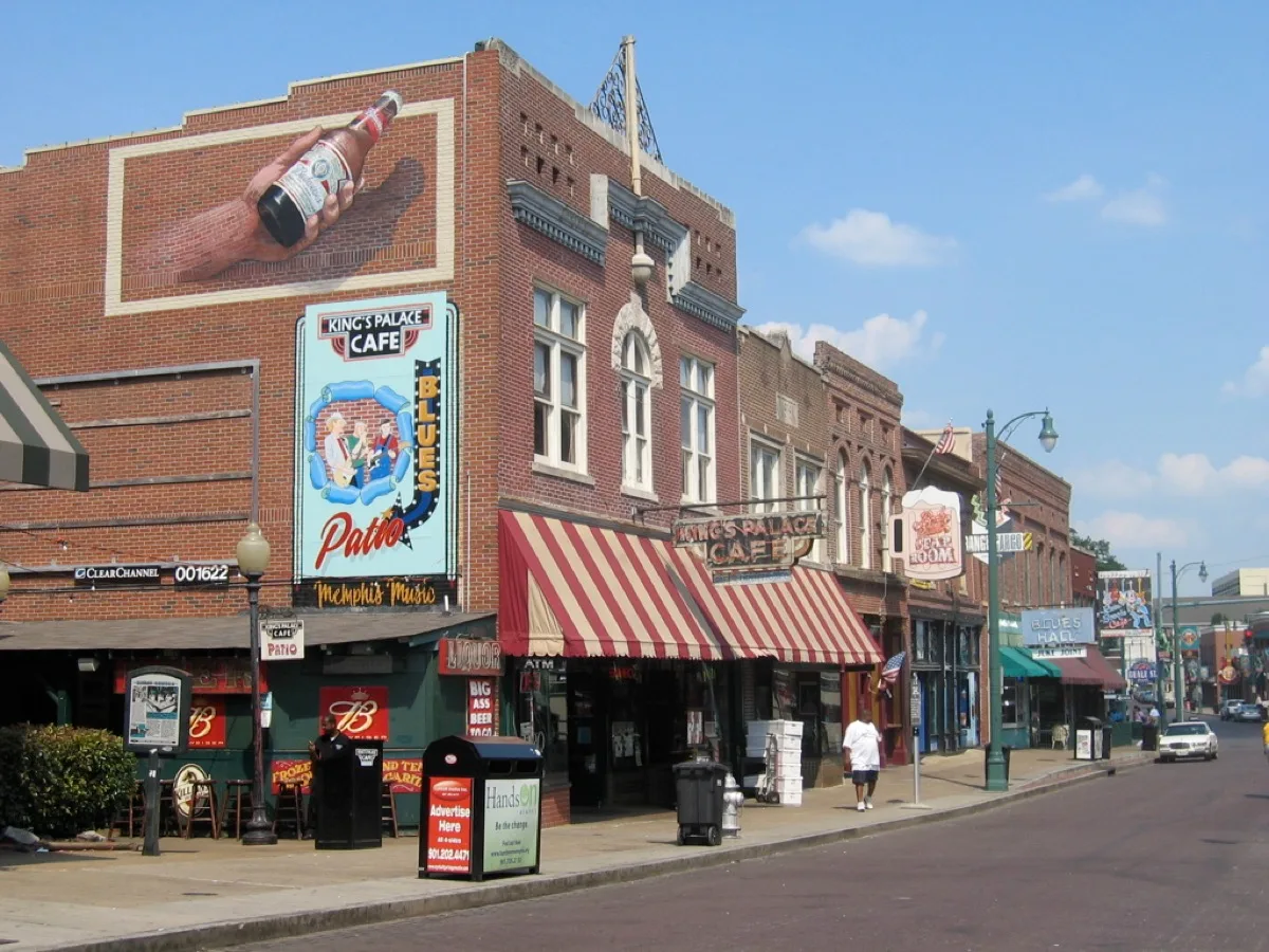
Memphis is heavier than Nashville. The Mississippi River is wide and brown and doesn't look like something you can cross. Beale Street still has the feeling of something real underneath the neon. The Civil Rights Museum will sit with you for days. The barbecue will too, but differently.
Sun Studio is where Elvis Presley, Johnny Cash, Jerry Lee Lewis, B.B. King, and Howlin' Wolf all recorded — the most important small room in American music history. The National Civil Rights Museum, built around the Lorraine Motel where Dr. King was assassinated, is one of the most important museums in the United States. The combination of these two places in one day is an experience unlike anything else on this route.
★ The moment
Walking through the National Civil Rights Museum and then stepping outside to stand beneath Room 306, where Dr. King stood on the balcony on April 4, 1968. The wreath is still there. It is very quiet.
⚠ Classic mistake
Going to Beale Street first and running out of time for Sun Studio and the Civil Rights Museum. Do the museums in the morning while you're fresh. Beale Street is for after.
📷 The photograph
At Sun Studio, they let you stand at the original microphone in the exact recording position. That's your photo. At the Civil Rights Museum, photograph the view of the balcony from the parking lot across the street — the same angle the shooter had.
⏱ How long do you need?
2 hours: Sun Studio tour only (1 hour) or Civil Rights Museum only. Full day: Sun Studio + Civil Rights Museum + Beale Street for dinner. This stop deserves a full day.
💬 What to ask
At Sun Studio, ask the guide to play the original acetate recording of Elvis's first session. They have it. The moment the guide drops the needle is something you won't forget.
Skip it if
There is no good reason to skip Memphis.
Don’t skip it if
Everyone. This is a non-negotiable stop.
Entry fee
Sun Studio: ~$15. Civil Rights Museum: ~$18.
Gas
Abundant throughout Memphis.
Don't miss eating
Sweet potato pie at Four Way Restaurant on Mississippi Boulevard — open since 1946, a civil rights-era institution where Dr. King himself ate, and the sweet potato pie is extraordinary. The vegetable plate here is a genuine Southern meal.
Website
memphistravel.com
This season
Spring / Summer
Memphis in May is a massive international barbecue championship — the city smells extraordinary and the energy is high. Book lodging ahead.
Summer / Fall
Heat in July and August is serious. Do outdoor things in the morning. The Civil Rights Museum is air-conditioned and worth the afternoon.
Fall / Winter
One of the best times to visit — mild, quiet, and the Lorraine Motel is deeply moving without summer tour buses.
Winter / Spring
February is Black History Month — the Civil Rights Museum has special programming. Quiet and powerful.
Average weather, all twelve months
| Jan | Feb | Mar | Apr | May | Jun | Jul | Aug | Sep | Oct | Nov | Dec | |
|---|---|---|---|---|---|---|---|---|---|---|---|---|
| High | 50° | 55° | 64° | 74° | 82° | 90° | 93° | 91° | 85° | 74° | 62° | 52° |
| Low | 31° | 34° | 42° | 52° | 60° | 69° | 72° | 71° | 64° | 52° | 41° | 33° |
| Rain | 3.8" | 3.7" | 5.0" | 5.3" | 4.6" | 3.5" | 3.7" | 2.9" | 3.0" | 3.0" | 4.7" | 4.6" |
Other options nearby
Things to do
Graceland
4.5★Museum
Elvis Presley's famed estate featuring mansion tours, exhibits, a car museum & 2 jets.
National Civil Rights Museum
4.9★Museum
Historic site of Martin Luther King, Jr.'s assassination & exhibits on the racial equality movement.
Memphis Botanic Garden
4.7★Botanical Garden
Global array of plants arranged into separate areas, including a popular Japanese tranquility space.
Shelby Farms Park
4.8★Park
4,500 acres with biking & horse trails, many bodies of water for fishing & boating plus playgrounds.
Sun Studio
4.8★Museum
Iconic 1950's studio where Elvis & Johnny Cash recorded with memorabilia on display & guided tours.
Food & drink
Charlie Vergos' Rendezvous
4.4★Barbecue Restaurant
Circa-1948 BBQ spot in a basement serving up racks of ribs & sausages cooked over charcoal.
B.B. King's Blues Club
4.6★Barbecue Restaurant
Blues fans come for live music & Southern food classics in a brightly decorated listening room.
Topgolf Memphis
3.4★Restaurant
Sprawling entertainment venue with a high-tech driving range & swanky lounge with drinks & games.
Central BBQ - Downtown
4.3★Barbecue Restaurant
Informal eatery with inventive meat dishes, from BBQ nachos to pork sandwiches & brisket platters.
Gus's World Famous Fried Chicken
4.6★Chicken Restaurant
Long-running chain serving spicy fried chicken & comfort sides in a low-key setting.
Stop 4
Oklahoma City, OK
On route — I-40
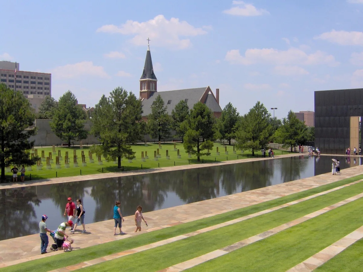
Oklahoma City is flatter than you expect and the sky is enormous. The memorial appears suddenly in the middle of the city — a long reflecting pool, 168 empty chairs, the silence of a Wednesday morning. It is not what you brace for. It is quieter and more devastating than that.
The Oklahoma City National Memorial commemorates the 168 people killed in the 1995 bombing — 168 chairs, one for each victim, arranged where the building stood, reflected in a still pool with an American elm that survived the blast still growing at one end. The attached museum traces the full story. This is one of the most thoughtfully designed memorials in the United States.
★ The moment
Standing at the Field of Empty Chairs at dusk, the chairs lit from below, one small chair in the children's section, and understanding the specific, individual scale of what happened here.
⚠ Classic mistake
Only walking the outdoor memorial and skipping the museum. The museum is where the story lives — the oral histories, the recovered objects, the sequence of the day. Allow 90 minutes for it.
📷 The photograph
The chairs from the east end of the reflecting pool at the golden hour before sunset — the light turns the glass chairs warm amber and the pool doubles them.
⏱ How long do you need?
90 minutes: outdoor memorial + museum. Half day: add the Bricktown canal walk and lunch.
💬 What to ask
At the museum entrance, ask about the Survivor Tree — the American elm that was in the parking lot directly across from the explosion. It's one of the most quietly powerful parts of the whole memorial.
Skip it if
You're emotionally spent from Memphis and need a lighter stop.
Don’t skip it if
You remember April 19, 1995. Most people your age do.
Entry fee
Outdoor memorial: free, open 24/7. Museum: ~$16/adult.
Gas
Abundant.
Don't miss eating
Green chile mac and cheese or the roasted vegetable tacos at Commonplace Books & Coffee in the Plaza District — a beloved OKC institution in a gorgeous independent bookshop. The kind of place you find by accident and remember forever.
Website
oklahomacitynationalmemorial.org
This season
Spring / Summer
Tornado season is April through June — keep a weather app open. The Myriad Botanical Gardens are beautiful in bloom alongside the memorial visit.
Summer / Fall
September and October are the best OKC weather. Bricktown is lively and pleasant in the evening.
Fall / Winter
The memorial in winter light with almost no other visitors is haunting and beautiful.
Winter / Spring
January is mild and manageable. A deeply educational stop on a quieter day.
Average weather, all twelve months
| Jan | Feb | Mar | Apr | May | Jun | Jul | Aug | Sep | Oct | Nov | Dec | |
|---|---|---|---|---|---|---|---|---|---|---|---|---|
| High | 48° | 54° | 63° | 73° | 81° | 90° | 96° | 95° | 86° | 75° | 61° | 51° |
| Low | 26° | 31° | 39° | 49° | 58° | 67° | 72° | 71° | 62° | 51° | 38° | 29° |
| Rain | 1.2" | 1.5" | 2.5" | 2.8" | 4.5" | 3.5" | 2.5" | 2.2" | 2.9" | 3.0" | 1.9" | 1.5" |
Other options nearby
Things to do
Newcastle Casino
3.8★Casino
Cards, electronic games & American bites plus bands, dancing & free outdoor summer concerts.
Oklahoma City National Memorial & Museum
4.9★Museum
A garden, pool & sculptural memorial commemorating victims of the 1995 Murrah Building bombing.
Science Museum Oklahoma
4.7★Museum
Expansive museum with child-friendly, hands-on exhibits, plus a planetarium & cafe.
Frontier City
4.0★Amusement Center
Western-themed amusement park offering thrill, kids' & water rides plus multiple shows & eateries.
National Cowboy & Western Heritage Museum
4.8★Museum
Dioramas, artifacts, art & more documenting & interpreting the history of the American West.
Food & drink
Cattlemen's Steakhouse
4.5★Steak House
Venerable eatery dishing house-aged beef, sides & more from morning to night in rustic digs.
Cinemark Tinseltown Oklahoma City and XD
4.5★Movie Theater
Chain of movie theaters, some with multiple screens, stadium seats & self-service ticketing kiosks.
Topgolf Oklahoma City
4.4★Restaurant
Sprawling entertainment venue with a high-tech driving range & swanky lounge with drinks & games.
Texas Roadhouse
4.4★Steak House
Lively chain steakhouse serving American fare with a Southwestern spin amid Texas-themed decor.
Tamashii Ramen House- Midtown
4.7★Ramen Restaurant
Japanese noodle soups with a variety of ingredients offered in a cozy, contemporary space.
Stop 5
Amarillo & Palo Duro Canyon, TX
25 min south of I-40
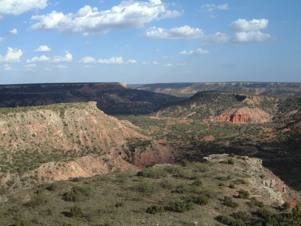
The Texas Panhandle looks like nothing, and then the ground opens. Palo Duro Canyon doesn't announce itself — you drive through flat scrubland and then the earth simply drops 800 feet. The colors are orange and red and purple and they're not subtle. And then there's Cadillac Ranch, which is exactly as bizarre as it sounds and exactly as delightful.
Palo Duro is the second-largest canyon in the United States — 800 feet deep, 120 miles long, and almost nobody outside Texas knows it exists. The layers of red, orange, and lavender rock span 250 million years of geology. Cadillac Ranch, just west of Amarillo on I-40, is ten Cadillacs buried nose-first in a wheat field as public art. It is free, you're encouraged to spray paint them, and it is uniquely and wonderfully American.
★ The moment
Standing on the canyon rim at sunrise watching the light fill the orange walls below while the valley floor is still in shadow. The silence is enormous.
⚠ Classic mistake
Stopping at Cadillac Ranch but skipping Palo Duro because it's a 25-minute detour south. Cadillac Ranch takes 20 minutes. Palo Duro Canyon takes your breath away.
📷 The photograph
At Palo Duro: the Lighthouse formation from the trail to its base — a 300-foot red rock column standing alone. At Cadillac Ranch: stand directly behind the row of cars at hood-level at sunrise — the tailfins against the wide Texas sky.
⏱ How long do you need?
1 hour: Cadillac Ranch. 2 hours: Palo Duro rim drive and one short overlook walk. Half day: Palo Duro with the canyon floor trail.
💬 What to ask
At the Palo Duro visitor center, ask about the 1874 Battle of Palo Duro Canyon — the largely untold story of how the canyon ended the era of the free Comanche people.
Skip it if
You've seen the Grand Canyon recently and canyon fatigue is real.
Don’t skip it if
You want to see something almost no one you know has seen.
Entry fee
Palo Duro State Park: ~$8/person. Cadillac Ranch: free.
Gas
Abundant in Amarillo.
Don't miss eating
Green chile cheese fries and a sopapilla with honey at any New Mexican-style diner as you cross into the Texas Panhandle — the influence of New Mexico cuisine bleeds east into Amarillo and the green chile here is the real thing. Or stop at Coyote Bluff Café for the best onion rings in the Texas Panhandle.
Website
palodurocanyon.com
This season
Spring / Summer
Wildflowers on the canyon rim in April are extraordinary. The Texas Musical outdoor drama runs summer evenings in the canyon amphitheater — worth staying for.
Summer / Fall
Very hot in July and August — enter the canyon before 8am. September cools off and the canyon light is golden and extraordinary.
Fall / Winter
October and November are the best months — mild temperatures, golden afternoon light, almost no other visitors.
Winter / Spring
January can be cold and very windy on the rim. Cadillac Ranch is always accessible regardless of weather.
Average weather, all twelve months
| Jan | Feb | Mar | Apr | May | Jun | Jul | Aug | Sep | Oct | Nov | Dec | |
|---|---|---|---|---|---|---|---|---|---|---|---|---|
| High | 49° | 54° | 63° | 73° | 81° | 91° | 94° | 91° | 84° | 74° | 61° | 51° |
| Low | 23° | 27° | 35° | 44° | 53° | 63° | 67° | 65° | 58° | 46° | 33° | 25° |
| Rain | 0.6" | 0.7" | 1.0" | 1.2" | 2.2" | 2.4" | 2.1" | 2.4" | 1.7" | 1.3" | 0.7" | 0.6" |
Other options nearby
Things to do
Palo Duro Canyon State Park
4.8★State Park
Big ravine with 800-ft cliffs, multi-use trails, campsites & the musical "Texas" in an amphitheater.
MERUS Adventure Park
4.9★Adventure Sports Center
Palo Duro Trading Post
4.6★Store
Shark Beach Burgers
4.8★Takeout Restaurant
Bar Z Winery
4.6★Winery
Food & drink
The Lumberyard Canyon
4.2★Restaurant
Buffalo Wild Wings
3.4★Chicken Wings Restaurant
Chain dishing up wings, tenders & burgers, plus sauces ranging from sweet to very spicy.
Shark Beach Burgers
4.8★Takeout Restaurant
Black Bear Diner Amarillo
4.0★American Restaurant
Easygoing chain serving familiar all-day comfort food & desserts in a woodsy setting.
McDonald's
2.9★Fast Food Restaurant
Classic, long-running fast-food chain known for its burgers & fries.
Stop 6
Albuquerque & Santa Fe, NM
Santa Fe is 60 min north of I-40 — worth the detour
New Mexico smells different — high desert sage, thin air, and something ancient underneath everything. Santa Fe looks like no other American city because it is like no other American city. The buildings are adobe, the light is gold, and the mountains behind it all are 13,000 feet. You will want to move there. Many people do.
Santa Fe is the oldest capital city in the United States, founded in 1610. The Georgia O'Keeffe Museum holds the world's largest collection of her work — desert skulls and canyon colors that suddenly make sense when you're standing in the landscape that inspired them. Old Town Albuquerque and the Indian Pueblo Cultural Center offer a genuine look at 19 living Pueblo nations whose ancestors have been in this place for a thousand years.
★ The moment
Walking Canyon Road in Santa Fe at the golden hour — a half-mile street of adobe galleries, each one lit warmly from inside, the Sangre de Cristo Mountains going pink behind everything. It is one of the most beautiful urban streets in America.
⚠ Classic mistake
Eating at a chain restaurant anywhere in New Mexico. This is one of the great regional food cultures in the United States. Every meal here should be local, and it should involve green chile.
📷 The photograph
The view from Canyon Road looking south at dusk — the road curving away, gallery lights warming the adobe walls, and the mountains catching the last light behind the city.
⏱ How long do you need?
Half day: O'Keeffe Museum + Canyon Road walk. Full day: add Old Town Albuquerque and the Indian Pueblo Cultural Center. Overnight: the ideal — wake up in Santa Fe and have breakfast at the Plaza.
💬 What to ask
At the Indian Pueblo Cultural Center, ask one of the Native guides which pueblo is closest to Albuquerque and whether it's open to visitors. Some are, on certain days, and that experience has no equivalent.
Skip it if
Art museums genuinely don't interest either of you. (Though the landscape alone is worth Santa Fe.)
Don’t skip it if
Either of you has ever been moved by a painting. O'Keeffe in her own landscape is a different experience than O'Keeffe in a museum in another city.
Entry fee
O'Keeffe Museum: ~$18. Indian Pueblo Cultural Center: ~$12.
Gas
Abundant in both cities.
Don't miss eating
Green chile stew (order it meatless — every New Mexican restaurant does this without blinking) and a sopapilla with honey at the Plaza Café in Santa Fe, open since 1947. New Mexican cuisine is one of the great regional food cultures in America and green chile on everything is non-negotiable.
Website
visitsantafe.com
This season
Spring / Summer
Santa Fe in May is perfect — cool, blooming, uncrowded. The O'Keeffe Museum is never crowded before 10am.
Summer / Fall
The Albuquerque Balloon Fiesta (first two weeks of October) is 500+ balloons filling the dawn sky. Book lodging 6+ months out.
Fall / Winter
Christmas in Santa Fe with farolito luminaria candles lining every rooftop is something else entirely. December 24 on Canyon Road is unforgettable.
Winter / Spring
February is quiet and often brilliantly sunny. The O'Keeffe Museum in winter feels intimate and unhurried.
Average weather, all twelve months
| Jan | Feb | Mar | Apr | May | Jun | Jul | Aug | Sep | Oct | Nov | Dec | |
|---|---|---|---|---|---|---|---|---|---|---|---|---|
| High | 47° | 52° | 60° | 70° | 78° | 88° | 91° | 88° | 82° | 71° | 57° | 47° |
| Low | 23° | 27° | 33° | 41° | 50° | 59° | 65° | 63° | 57° | 45° | 32° | 23° |
| Rain | 0.5" | 0.5" | 0.6" | 0.6" | 0.6" | 0.9" | 1.4" | 1.5" | 1.0" | 0.8" | 0.5" | 0.5" |
Other options nearby
Things to do
Santa Fe Plaza
4.7★Historical Landmark
Historic city plaza with benches, a bandstand & ethnic markets, plus festivals & community events.
Georgia O'Keeffe Museum
4.6★Museum
Rotating exhibits of the work of Georgia O'Keeffe include paintings, sculptures & sketches.
Ski Santa Fe
4.6★Ski Resort
Play Poker Online
4.1★Casino
New Mexico State Capitol
4.5★Local Government Office
Round building featuring a central hall with a stained-glass ceiling, plus sculpture-dotted grounds.
Food & drink
Tomasita's Santa Fe - New Mexican Restaurant
4.5★Southwestern Restaurant (US)
Lively go-to for enchiladas, sopapillas, flautas & more Southwestern favorites amid basic decor.
The Shed
4.4★American Restaurant
Local go-to for classic Southwestern fare housed in a circa-1692 hacienda with a cantina-style bar.
Ten Thousand Waves
4.6★Spa
Secluded, Japanese-themed lodging with cozy rooms & suites, a chic spa & an Asian restaurant.
Cafe Pasqual's
4.5★Southwestern Restaurant (US)
Mexican fare from local & organic ingredients along with a community table in a historic adobe.
La Choza Restaurant
4.6★Mexican Restaurant
Casual eatery with colorful decor features tacos, burritos & more with a separate vegetarian menu.
Stop 7
Petrified Forest & Painted Desert, AZ
Straddles I-40 — pull off the highway
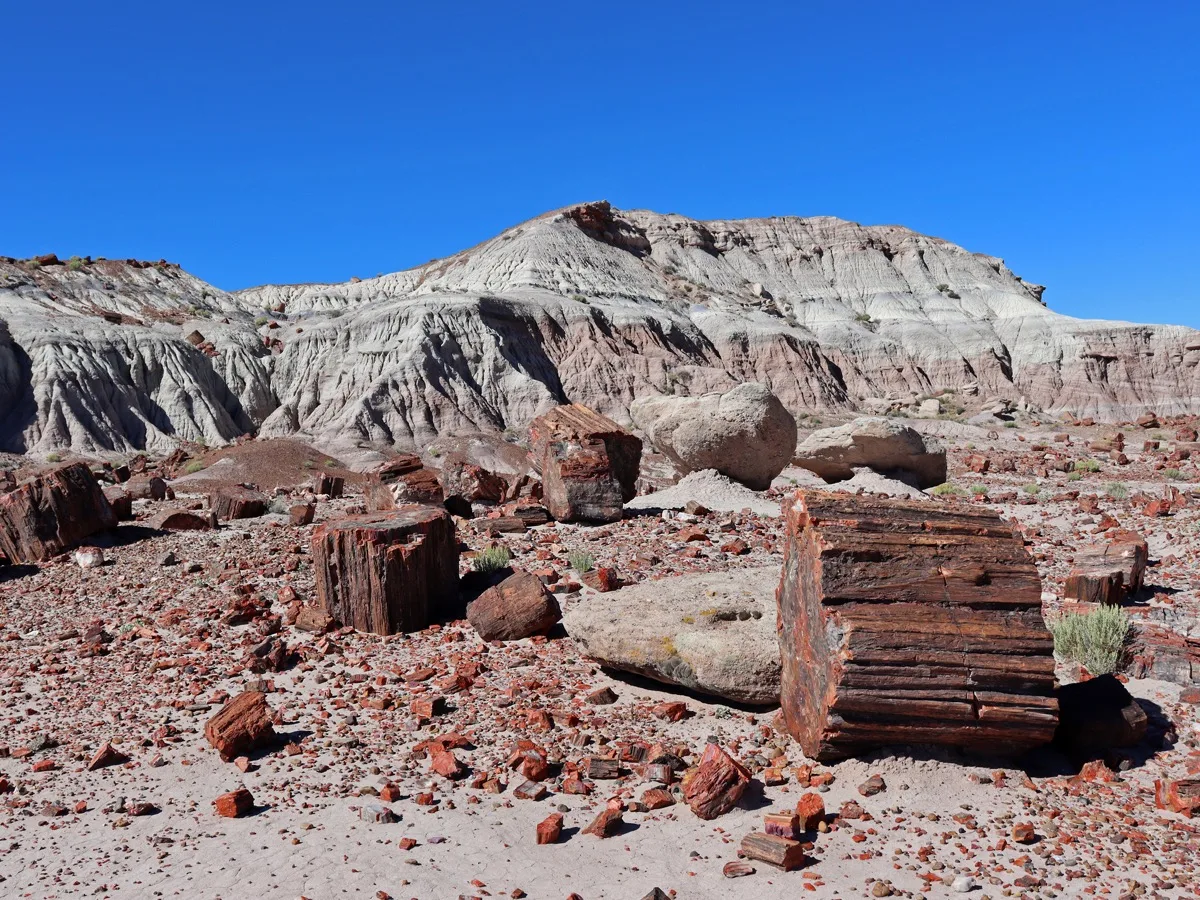
The Painted Desert looks like someone airbrushed the land in bands of lavender, pink, cream, and rust. The petrified logs look like someone left enormous jewels scattered on the ground. Everything here is 225 million years old. The silence and the scale work on you slowly — it takes a few minutes to adjust to being in a landscape this old.
Ancient trees fell into a river 225 million years ago, were buried in volcanic ash, and were slowly replaced mineral by mineral with quartz crystal and iron oxide. What's left are enormous crystal logs scattered across a Mars-colored desert, some of them 6 feet in diameter and 100 feet long. The park straddles I-40 — you can enter one side, drive through, and exit the other without backtracking.
★ The moment
Getting out of the car at Blue Mesa and standing on the eroded badland hills surrounded by crystal logs in every direction, the painted desert stretching to the horizon, and realizing you're standing on the floor of an ancient inland sea.
⚠ Classic mistake
Driving through without stopping. This is not a place to see from the car. Pull off at Blue Mesa and walk the 1-mile loop — it takes 30 minutes and is unlike anything else on the trip.
📷 The photograph
Blue Mesa: crouch low on the trail and photograph a crystal log close up against the painted badland hills behind it — the colors of the log and the hills match in an almost unreal way.
⏱ How long do you need?
1 hour: drive-through with two or three pullouts. 2 hours: Blue Mesa loop trail + Painted Desert rim overlooks. Half day: add the Tepees formation and Agate Bridge.
💬 What to ask
Ask at the visitor center why you can't take even a small piece of petrified wood. The answer — that the park loses 12 tons of petrified wood per year to theft despite it being a federal crime — is both startling and clarifying.
Skip it if
You genuinely have no patience for geology or very old things.
Don’t skip it if
You want to walk on something 225 million years old. You do.
Entry fee
$25/vehicle. America the Beautiful Pass accepted (and worth buying here if you haven't yet).
Gas
Fill up in Holbrook, AZ (west entrance) or Gallup, NM (east). Very limited inside the park.
Don't miss eating
Navajo fry bread at a roadside stand on the nearby Navajo Nation — golden, puffy, served with honey or as an Indian taco. A genuine and delicious experience you can't get elsewhere.
Website
nps.gov/pefo
This season
Spring / Summer
April and May are ideal — wildflowers in the painted desert, comfortable temperatures, beautiful morning light.
Summer / Fall
Monsoon season (July–September) brings dramatic clouds and extraordinary rainbow light over the painted formations.
Fall / Winter
October is arguably the best month — golden afternoon light, cool air, almost no other visitors.
Winter / Spring
Snow on petrified crystal logs is a sight almost no one has ever seen. Worth stopping if conditions allow.
Average weather, all twelve months
| Jan | Feb | Mar | Apr | May | Jun | Jul | Aug | Sep | Oct | Nov | Dec | |
|---|---|---|---|---|---|---|---|---|---|---|---|---|
| High | 45° | 51° | 58° | 67° | 76° | 86° | 88° | 84° | 79° | 68° | 55° | 46° |
| Low | 19° | 23° | 29° | 36° | 45° | 54° | 61° | 58° | 52° | 40° | 28° | 20° |
| Rain | 0.6" | 0.6" | 0.7" | 0.4" | 0.4" | 0.3" | 1.4" | 1.5" | 1.0" | 0.8" | 0.5" | 0.7" |
Other options nearby
Things to do
Petrified Forest National Park
4.8★National Park
Picturesque natural attraction with many petrified tree trunks & fossils, plus ranger-led tours.
Rainbow Forest Museum and Visitor Center
4.7★Museum
Painted Desert Inn
4.7★Museum
Storied Pueblo Revival–style adobe inn, now a museum with Hopi murals & a seasonal ice cream parlor.
Crystal Forest
4.8★Scenic Spot
Giant Logs Trail
4.8★Hiking Area
Food & drink
Petrified Forest Trading Company
4.1★Restaurant
Painted Desert Diner
3.6★Restaurant
Stop 8
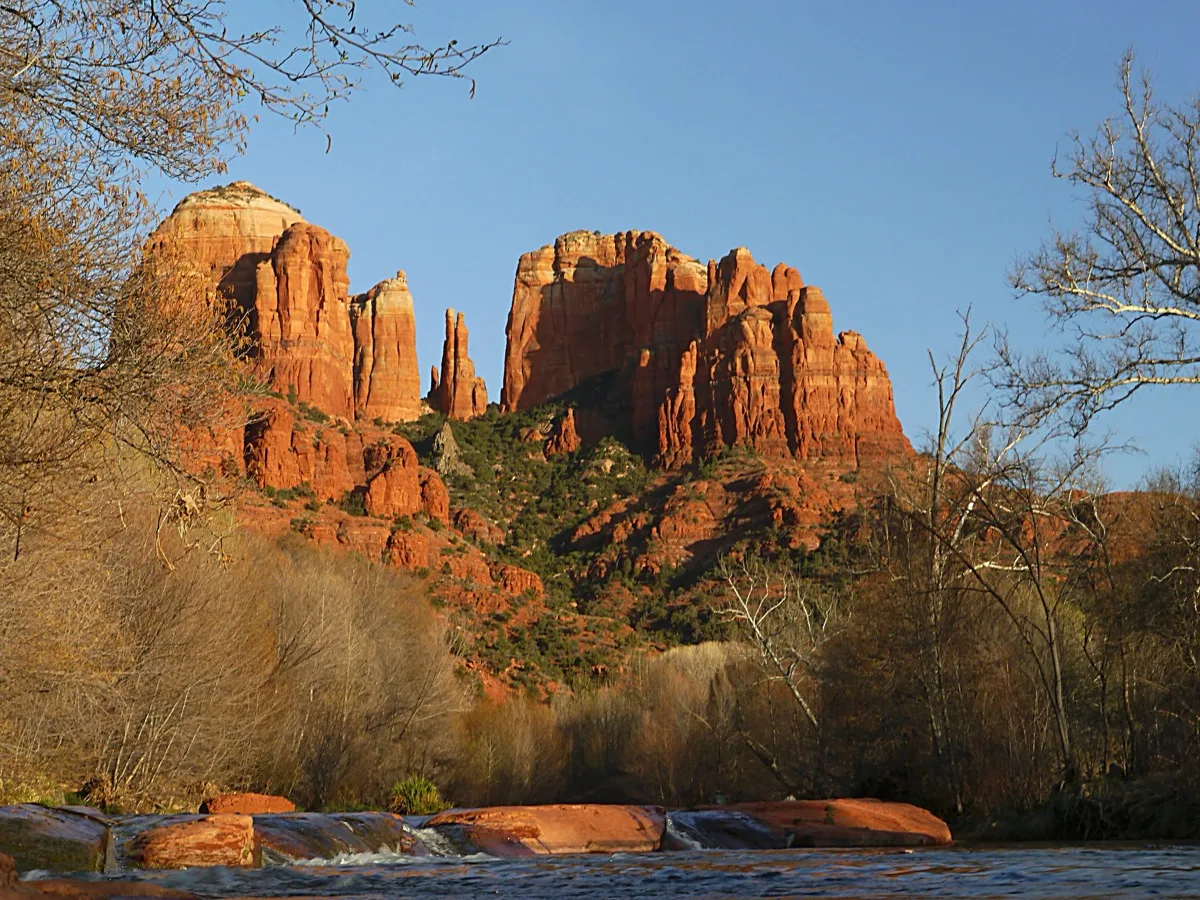
Sedona, AZ
~45 min south of I-40 via AZ-89A
Sedona is almost too beautiful to be real. The red sandstone buttes don't rise gradually — they erupt out of the desert floor fully formed, like someone placed them there. At sunrise and sunset they glow a deep copper-orange that seems to come from inside the rock rather than from reflected light. The Chapel of the Holy Cross appears suddenly on the cliff face and stops you cold.
Cathedral Rock, Bell Rock, and the Chapel of the Holy Cross — a modernist glass-and-concrete church fused into a 1,000-foot red rock spire in 1956 — are the anchors. The drive in through Oak Creek Canyon on AZ-89A from Flagstaff is itself one of the great scenic drives in the Southwest. Sedona is the kind of place that changes people's minds about what American landscape is capable of.
★ The moment
The Chapel of the Holy Cross at sunset — stepping inside the glass front and looking out through the cross-shaped window at the canyon turning copper and crimson below. It is free, open late, and almost no one is prepared for how it feels.
⚠ Classic mistake
Spending your time in Sedona shopping. The town is full of crystals and art galleries and they're pleasant. But Airport Mesa Road at sunset costs nothing and is a hundred times more powerful.
📷 The photograph
Airport Mesa overlook at sunset — position yourself on the left side of the pullout, looking southwest. Cathedral Rock, Bell Rock, and Courthouse Butte all line up in the distance as the sky turns every shade of orange at once.
⏱ How long do you need?
2 hours: Chapel of the Holy Cross + Airport Mesa sunset. Half day: add Oak Creek Canyon drive and Cathedral Rock viewpoint. Full day: everything plus a morning walk at Red Rock Crossing.
💬 What to ask
At the Chapel of the Holy Cross, ask one of the volunteers about Marguerite Brunswig Staude, the sculptor who built it. She fought for 20 years to get it approved and built it after being inspired by the Empire State Building. That story makes the chapel mean something different.
Skip it if
You're doing Joshua Tree and the Grand Canyon and red rock saturation is a real concern. (Though Sedona is different enough to warrant the stop.)
Don’t skip it if
Either of you is moved by beauty. This place is relentless with it.
Entry fee
No park entry fee. Red Rock Pass required at trailheads: ~$5–12/day.
Gas
Abundant in Sedona.
Don't miss eating
Anything at Elote Café — especially the titular roasted corn. One of the best restaurants in Arizona. Book ahead.
Website
visitsedona.com
This season
Spring / Summer
April and May are ideal — wildflowers blooming against the red rock. Book restaurants and popular trailhead parking weeks ahead.
Summer / Fall
Monsoon storm light in August on the red formations is otherworldly. October is excellent and somewhat calmer than summer.
Fall / Winter
December and January are quiet and often perfectly clear. The Chapel in winter silence is deeply moving.
Winter / Spring
March is uncrowded and the light is extraordinary. Occasional snow on the red rocks — one of the rarest and most beautiful sights in the Southwest.
Average weather, all twelve months
| Jan | Feb | Mar | Apr | May | Jun | Jul | Aug | Sep | Oct | Nov | Dec | |
|---|---|---|---|---|---|---|---|---|---|---|---|---|
| High | 55° | 59° | 65° | 73° | 82° | 92° | 96° | 93° | 88° | 77° | 63° | 55° |
| Low | 32° | 35° | 40° | 46° | 54° | 62° | 70° | 68° | 63° | 52° | 40° | 33° |
| Rain | 1.7" | 1.8" | 2.1" | 1.0" | 0.6" | 0.3" | 1.9" | 2.2" | 1.7" | 1.4" | 1.4" | 1.7" |
Other options nearby
Things to do
Chapel of the Holy Cross
4.8★Church
Modern 1950s chapel with a striking location atop red rock buttes & wide views of the Sedona area.
Montezuma Castle National Monument
4.7★National Park
Cliff dwelling ruins of the Sinagua people dating back to the 12th century overlooking Beaver Creek.
Devil's Bridge Trailhead
4.8★Hiking Area
Moderate, 1.8-mi. roundtrip hike to a towering sandstone arch, which visitors can also walk across.
Cathedral Rock Trailhead
4.8★Hiking Area
Unshaded 1.5-mile round-trip trail ascending steeply to a saddle between rock formations.
Verde Canyon Railroad
4.7★Tourist Attraction
4-hour train tours through red-rock landscapes with open-air viewing cars, food & cocktails.
Food & drink
Tlaquepaque Arts & Shopping Village
4.6★Shopping Mall
Enduring outdoor market featuring art galleries, craft shops, cobblestone paths & decorative arches.
McDonald’s
4.0★Fast Food Restaurant
The Hudson
4.6★American Restaurant
Neighborhood restaurant serving New American fare & cocktails in chic, contemporary surroundings.
Mariposa Latin Inspired Grill
4.4★Latin American Restaurant
Upscale restaurant & bar with South American-inspired cuisine, a patio & panoramic views.
Wildflower
4.5★American Restaurant
Local cafe chain serving high-end sandwiches, salads & baked goods in a counter-serve setting.
Stop 9
Grand Canyon — South Rim, AZ
90 min north of I-40 via AZ-64
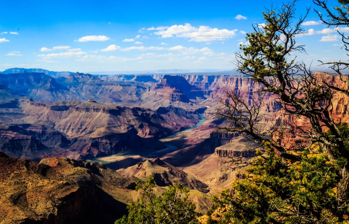
Everyone thinks they know what the Grand Canyon looks like. They have seen the photographs. They are wrong. No photograph prepares you for the moment your brain fails to process the scale — a mile deep, ten miles across, 277 miles long. People laugh nervously. Some people cry. It is involuntary. It is one of the defining experiences a human being can have, and it is available to anyone willing to drive 90 minutes off I-40.
The Colorado River took six million years to carve through 1.8 billion years of exposed rock. The South Rim sits at 7,000 feet. The river is a mile below. The canyon is so large that it has its own weather systems — it can be clear on the rim while a thunderstorm moves through the inner canyon below you. You can see it all from the rim without any hiking.
★ The moment
Mather Point at sunrise. Stand at the rim as the first light hits the upper canyon walls and moves downward in a slow, deepening cascade of gold, orange, and rose. It takes about 20 minutes. You will not speak during those 20 minutes.
⚠ Classic mistake
Arriving at noon in summer and leaving because it's 100°F on the rim. Come at sunrise. The difference between the Grand Canyon at noon in July and the Grand Canyon at 6am is the difference between a postcard and a spiritual experience.
📷 The photograph
Mather Point at sunrise, facing east. The canyon walls catch the light from the top down — position yourself on the left side of the overlook and shoot toward the inner canyon as the shadow line descends the walls. This is the photograph.
⏱ How long do you need?
2 hours: Mather Point + Yavapai Geology Museum. Half day: add the Rim Trail walk west to Maricopa Point (2 miles, flat). Full day: Hermit Road shuttle for the classic canyon views, sunrise AND sunset.
💬 What to ask
Ask a ranger at Mather Point how old the rocks at the very bottom of the canyon are. The answer — 1.8 billion years, nearly half the age of the Earth — takes a moment to land.
Skip it if
There is no justification for skipping the Grand Canyon.
Don’t skip it if
You are alive and on this route.
Entry fee
$35/vehicle (7-day pass). America the Beautiful Pass accepted.
Gas
Desert View (east entrance) and Tusayan, just south of the main entrance.
Don't miss eating
Breakfast on the El Tovar porch overlooking the canyon — book a table the moment you make lodging reservations. The food is secondary. The view from that porch at 7am is not.
Website
nps.gov/grca
This season
Spring / Summer
April is the sweet spot — cool rim temperatures, no summer crowds yet. Rim lodging books 12+ months in advance. The sunrise at Mather Point requires no hiking and no planning beyond being there.
Summer / Fall
July and August bring afternoon thunderstorms that move through the inner canyon below you — one of the most dramatic natural spectacles you will ever see from a safe, comfortable rim. October is superb.
Fall / Winter
December and January on the rim with snow and almost no other visitors is something people return from changed. The canyon in snow is beyond any description we can offer.
Winter / Spring
February is the most underrated month — thin crowds, crisp clear air, and the winter light turns the canyon colors deeper and warmer.
Average weather, all twelve months
| Jan | Feb | Mar | Apr | May | Jun | Jul | Aug | Sep | Oct | Nov | Dec | |
|---|---|---|---|---|---|---|---|---|---|---|---|---|
| High | 42° | 47° | 54° | 63° | 73° | 83° | 84° | 81° | 76° | 65° | 52° | 43° |
| Low | 19° | 23° | 28° | 35° | 44° | 53° | 61° | 60° | 53° | 41° | 30° | 21° |
| Rain | 1.3" | 1.4" | 1.3" | 0.8" | 0.5" | 0.4" | 1.8" | 2.2" | 1.6" | 1.0" | 0.7" | 1.5" |
Other options nearby
Things to do
Grand Canyon Visitor Center
4.7★Visitor Center
Hub for park information, bike rentals, coffee, exhibits & historical artifacts, plus a gift shop.
Mather Point
4.9★Landmark
Scenic viewpoint along South Rim, popular for its canyon vistas & proximity to the visitor center.
North Rim Visitor Center
4.7★Visitor Center
Ranger-staffed resource for Grand Canyon views & educational information, plus a bookstore.
Hopi Point
4.9★Landmark
South Rim overlook with unobstructed canyon vistas & popular stop for sunrise & sunset viewing.
Grandview Point
4.9★Scenic Spot
South Rim viewpoint overlooking a panorama of colorful canyons, ridges & the snaking Colorado River.
Food & drink
El Tovar Dining Room
4.2★Fine Dining Restaurant
Elegant American restaurant inside the El Tovar Hotel with Grand Canyon vistas from some tables.
Yavapai Tavern
4.0★Sports Bar
Stone-accented watering hole offering regional craft beers, specialty cocktails & a pub-grub menu.
We Cook Pizza and Pasta
4.0★Pizza Restaurant
Diners sit at picnic tables while sampling this basic eatery's Italian standards & salad bar.
Foodie Club
4.3★Restaurant
Straightforward choice for counter-service sandwiches, salads & all-day breakfast.
Plaza Bonita Restaurant
4.1★Mexican Restaurant
Local Mexican chain serving classic dishes & margaritas in a casual, traditional setting.

Stop 10
Joshua Tree National Park, CA
~2 hours south of I-40 via US-95 and CA-62
Joshua Tree is strange and still and a little bit eerie in the best possible way. The trees themselves look like they were drawn by someone who had never seen a tree — arms reaching in every direction, no leaves, covered in spines. The boulders are enormous and smooth and warm to the touch. At night, when the stars come out, it becomes something else entirely.
The Mojave and Sonoran deserts collide here, creating a landscape unlike anywhere else on Earth. The Joshua trees (actually a species of yucca) exist only in this narrow elevation band of the Mojave. The Cholla Cactus Garden at sunset is a half-mile of cacti that seem to glow orange from inside. The night sky is among the clearest in the Lower 48.
★ The moment
Lying on a flat boulder in the park on a clear night watching the Milky Way stretch from one horizon to the other. More stars than you have ever seen in your life. More than you knew existed. Let your eyes adjust for 15 minutes and it gets more extraordinary.
⚠ Classic mistake
Going to Joshua Tree in July or August. Temperatures exceed 115°F. It is genuinely dangerous. This stop belongs to October through April.
📷 The photograph
Cholla Cactus Garden at sunset — position yourself so the setting sun is behind you and the cacti are backlit. Each spine glows individually. The effect is impossible to believe until you see it.
⏱ How long do you need?
2 hours: Cholla Cactus Garden at sunset + one boulder area. Half day: add Skull Rock trail and Hidden Valley. Full day: everything plus nighttime stargazing.
💬 What to ask
Ask a ranger about the Joshua tree's relationship with the yucca moth — the tree cannot reproduce without it, and the moth cannot survive without the tree. It's one of the most elegant partnerships in nature and tells you something about how this desert works.
Skip it if
You're visiting in high summer. Come back another time.
Don’t skip it if
You have never seen a truly dark sky. A night here will recalibrate what you thought the universe looked like.
Entry fee
$30/vehicle (7-day pass).
Gas
Twentynine Palms at the north entrance; Palm Springs 40 min south for abundant options.
Don't miss eating
Date shakes at Hadley Fruit Orchards near Cabazon, CA — the Coachella Valley produces some of the world's finest Medjool dates, and the milkshake made from them is unlike anything you can get elsewhere.
Website
nps.gov/jotr
This season
Spring / Summer
March–April: wildflower superbloom in good rain years — fields of gold and orange across the desert floor. Check bloomchasers.com before routing here.
Summer / Fall
Only visit in October or later if departing in this window. October sunsets over the Cholla Garden are extraordinary.
Fall / Winter
October through February is the ideal season — mild days, cold clear nights, and the Milky Way on any cloudless evening.
Winter / Spring
January is perfect: highs in the 60s, almost no crowds, and the night sky is staggering.
Average weather, all twelve months
| Jan | Feb | Mar | Apr | May | Jun | Jul | Aug | Sep | Oct | Nov | Dec | |
|---|---|---|---|---|---|---|---|---|---|---|---|---|
| High | 60° | 64° | 71° | 80° | 90° | 99° | 106° | 104° | 98° | 86° | 71° | 62° |
| Low | 36° | 39° | 44° | 51° | 60° | 68° | 76° | 74° | 68° | 57° | 44° | 37° |
| Rain | 0.8" | 0.8" | 0.5" | 0.2" | 0.1" | 0.0" | 0.4" | 0.6" | 0.3" | 0.3" | 0.3" | 0.5" |
Other options nearby
Things to do
Joshua Tree National Park
4.8★National Park
Renowned desert park draws campers & hikers with its geologic wonders & signature Joshua trees.
Cottonwood Visitor Center
4.6★Visitor Center
A gateway to trails in Cottonwood Spring, this small center has a gift shop & park displays.
Arch Rock
4.7★Scenic Spot
Large natural rock formation, some 30 ft. across, along the 0.5-mi. Arch Rock desert loop trail.
Jumbo Rocks Campground
4.8★Campground
Popular campground in desert wilderness ringed by large boulders, desert scrub & miniature canyons.
Skull Rock Trail
4.6★Hiking Area
Skull-shaped desert granite rock formation with 2 depressions like eye sockets created by erosion.
Stop 11
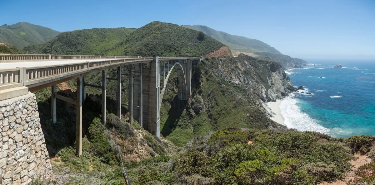
Big Sur & Pacific Coast Highway, CA
~2 hours west of I-5 — plan a full day
The Pacific Coast Highway through Big Sur is one of those drives that you have seen in car commercials your whole life, and it is better than the commercials. The Santa Lucia Mountains drop directly into the ocean with no beach between them. The scale of the cliffs, the color of the water, the fog coming in from the Pacific in the morning — it operates on a frequency that is hard to describe and impossible to forget.
Highway 1 through Big Sur hugs 90 miles of coast where 4,000-foot cliffs meet the Pacific Ocean. Bixby Bridge spans a sea-carved canyon 260 feet above the ocean. McWay Falls drops 80 feet onto a private beach cove that no human can reach. Every single pullout on this road rewards stopping.
★ The moment
Pulling off at Bixby Bridge and walking to the overlook as the late afternoon fog starts rolling in from the Pacific below the bridge. The fog moves slowly. The bridge is very orange. The canyon below it is very deep. The ocean beyond is very blue. This is one of the great views in the United States.
⚠ Classic mistake
Running out of gas. This is not a metaphor. There is no gas for 90 miles between Carmel and San Simeon. Fill the tank completely in Carmel before heading south on Highway 1. This mistake has stranded many people.
📷 The photograph
Bixby Bridge from the north overlook pullout, late afternoon — position the bridge in the lower third of the frame with the canyon below it and the ocean in the background. The fog in the canyon below the bridge is the bonus.
⏱ How long do you need?
Half day: drive Highway 1 with pullouts at Bixby Bridge and McWay Falls. Full day: add Point Lobos State Reserve north of Carmel (one of the most beautiful parks in California) and a long lunch at Nepenthe.
💬 What to ask
At Nepenthe restaurant, ask your server about the cabin on the property that Orson Welles bought for Rita Hayworth as a honeymoon cottage. It's still there, now used as a wine bar above the main restaurant.
Skip it if
Highway 1 is closed due to slides or storm damage — check conditions at dot.ca.gov before committing to this route.
Don’t skip it if
You want to drive one of the most beautiful roads on Earth. This is it.
Entry fee
Julia Pfeiffer Burns State Park (McWay Falls): ~$10/vehicle. Highway 1 itself is free.
Gas
CRITICAL: Fill completely in Carmel before heading south. No gas for 90 miles.
Don't miss eating
The vegetable plate and fresh-baked bread at Nepenthe restaurant — perched 800 feet above the Pacific, serving food since 1949. Nepenthe has always done excellent vegetarian food alongside everything else. The view while eating it is the point regardless of what's on the plate.
Website
visitcalifornia.com/region/big-sur
This season
Spring / Summer
May and June bring morning sea fog that burns off by noon — beautiful and atmospheric. Wildflowers on the coastal bluffs in April and May.
Summer / Fall
July is classic Big Sur — warm, clear, ocean calm. The ideal driving month.
Fall / Winter
November and December: gray whale migration begins. Watch from any pullout. Storm light on the coast is dramatic and worth it.
Winter / Spring
Check road conditions carefully — Highway 1 can close after heavy rains. When open in January, the coast is hauntingly empty and beautiful.
Average weather, all twelve months
| Jan | Feb | Mar | Apr | May | Jun | Jul | Aug | Sep | Oct | Nov | Dec | |
|---|---|---|---|---|---|---|---|---|---|---|---|---|
| High | 59° | 62° | 63° | 65° | 67° | 69° | 70° | 71° | 72° | 70° | 65° | 59° |
| Low | 43° | 45° | 46° | 48° | 51° | 54° | 55° | 56° | 55° | 52° | 47° | 43° |
| Rain | 4.8" | 4.0" | 3.5" | 1.5" | 0.5" | 0.1" | 0.0" | 0.1" | 0.4" | 1.5" | 3.0" | 4.0" |
Other options nearby
Things to do
Point Lobos State Natural Reserve
4.9★State Park
Scenic coastal area featuring diverse sea animals & wildlife, hiking, diving & a whaling museum.
Pebble Beach Golf Links
4.8★Golf Course
Famed & highly touted 18-hole coastline public golf course with dramatic sea views & a clubhouse.
Carmel Mission Basilica
4.6★Church
Venerable, circa-1771 church featuring an on-site museum, a serene courtyard, tours & more.
Garrapata State Park
4.8★State Park
Park with 2 miles of beachfront & coastal hiking, including a 50-foot climb to a Pacific Ocean view.
Lone Cypress
4.7★Scenic Spot
Fenced viewpoint for a landmark single cypress tree overlooking the Pacific Ocean.
Food & drink
Nepenthe
4.5★American Restaurant
Eatery perched on a Big Sur cliffside offering California fare & a terrace with breathtaking views.
La Bicyclette Restaurant
4.5★European Restaurant
Cozy European bistro offering French-Italian fare on a weekly-changing menu.
Mission Ranch Restaurant
4.6★American Restaurant
Serving American comfort food in a farmhouse restored by Clint Eastwood with pastural views.
Stationæry
4.2★Restaurant
Compact, neighborhood restaurant serving brunch, dinner & wine in a laid-back ambiance.
Carmel Bakery
4.3★Bakery
Quaint 1906 bakeshop dispensing European-style pastries & pretzels, coffee, soups & sandwiches.
Stop 12
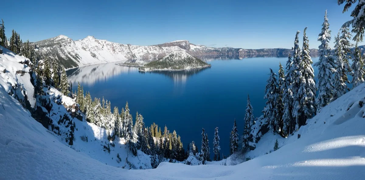
Crater Lake, OR
~3 hours east of I-5 — do not talk yourself out of this
You will not believe the color. You will have seen photographs of Crater Lake's blue and thought: that's a filter, that's enhanced. It is not. The blue is real and it is violent — a blue so saturated and so deep that your brain cannot quite accept it as water. Standing at the rim and looking into it produces a specific kind of silence. People stop talking. They just look.
Crater Lake is the deepest lake in the United States — 1,943 feet — and it has no inlet or outlet. Every drop of water in it fell as rain or snow into the collapsed caldera of a volcano that erupted 7,700 years ago. The water is so pure and so deep that it absorbs all light except the deepest blue wavelengths. Wizard Island rises from the center. The rim is a 33-mile circle of volcanic cliffs above this impossible blue.
★ The moment
Walking to the rim for the first time and seeing the blue. Not reading about the blue. Not seeing a photograph of the blue. Seeing it. Your first reaction will be that it doesn't look real. Your second will be that it is the most beautiful thing you have ever seen.
⚠ Classic mistake
Driving to Crater Lake and looking at it from one overlook before driving away. Take Rim Drive — even part of it. The lake looks different from every point on the circle. Wizard Island changes shape. The cliffs change color. Give it two hours minimum.
📷 The photograph
Cloudcap overlook on the east rim — the highest point on Rim Drive — looking southwest. Wizard Island is centered in the frame below you, the entire caldera spread out, and the blue is at its most intense from this angle and elevation.
⏱ How long do you need?
2 hours: Rim Village + Discovery Point overlook. Half day: partial Rim Drive to Cloudcap (highest point, best view down into the caldera). Full day: complete Rim Drive with all overlooks + the boat tour to Wizard Island.
💬 What to ask
Ask a ranger how deep 1,943 feet actually is. The answer — that the Empire State Building submerged in it would have 500 feet of water over the top — takes a moment to process.
Skip it if
Rim Drive is not yet open for the season (check nps.gov/crla — it typically opens late June).
Don’t skip it if
You want to see something that will change how you understand the word 'blue.'
Entry fee
$35/vehicle (7-day pass). Wizard Island boat tour: ~$55, book at recreation.gov months in advance.
Gas
Fill in Medford or Klamath Falls before entering the park. Very limited inside.
Don't miss eating
Breakfast at the Crater Lake Lodge dining room, overlooking the lake. Book when you make your lodging reservation. The French toast is good. The view is everything.
Website
nps.gov/crla
This season
Spring / Summer
Rim Drive typically opens in late June or early July — call ahead. Wildflowers along the rim in July are extraordinary alongside the blue.
Summer / Fall
Late September is the last good window before Rim Drive closes for snow in October. Perfect temperatures and almost no crowds.
Fall / Winter
Winter access is limited to the north entrance. The lake in snow is hauntingly beautiful — check road conditions.
Winter / Spring
Too early in spring and snow gates will be closed. Rim Drive doesn't usually open until late June. Check nps.gov/crla.
Average weather, all twelve months
| Jan | Feb | Mar | Apr | May | Jun | Jul | Aug | Sep | Oct | Nov | Dec | |
|---|---|---|---|---|---|---|---|---|---|---|---|---|
| High | 33° | 35° | 39° | 46° | 55° | 63° | 73° | 73° | 65° | 54° | 41° | 34° |
| Low | 18° | 18° | 21° | 27° | 33° | 39° | 46° | 46° | 40° | 33° | 26° | 20° |
| Rain | 9.5" | 8.0" | 8.0" | 5.0" | 3.5" | 1.5" | 0.4" | 0.6" | 1.5" | 4.0" | 9.0" | 11.0" |
Other options nearby
Things to do
Crater Lake National Park
4.9★National Park
183,224-acre park containing America's deepest lake, striking geologic features & a historic lodge.
Rim Visitor Center
4.6★Visitor Center
Visitor facility with nature exhibits, bookstore, scenic lake views & access to Garfield Peak Trail.
Cleetwood Cove Trail
4.8★Hiking Area
Cove with dock for boat tours, reached by a steep 1.1-mi. hiking trail from Rim Drive.
Watchman Peak Trailhead, Crater Lake
4.9★Hiking Area
Cloudcap Overlook
4.9★Landmark
Scenic overlook at the end of highest paved road in Oregon, offering panoramic lake views.
Food & drink
Rim Village Café and Gift Shop
4.0★Cafe
Quaint mountaintop counter-serve option with patio seating serving sandwiches & salads.
Annie Creek Restaurant and Gift Shop
3.8★American Restaurant
National park eatery with a gift shop serving traditional American fare such as burgers & shakes.
Crater Lake Lodge Dining Room
3.7★American Restaurant
South Shore Pizza
4.4★Pizza Restaurant
Stop 13
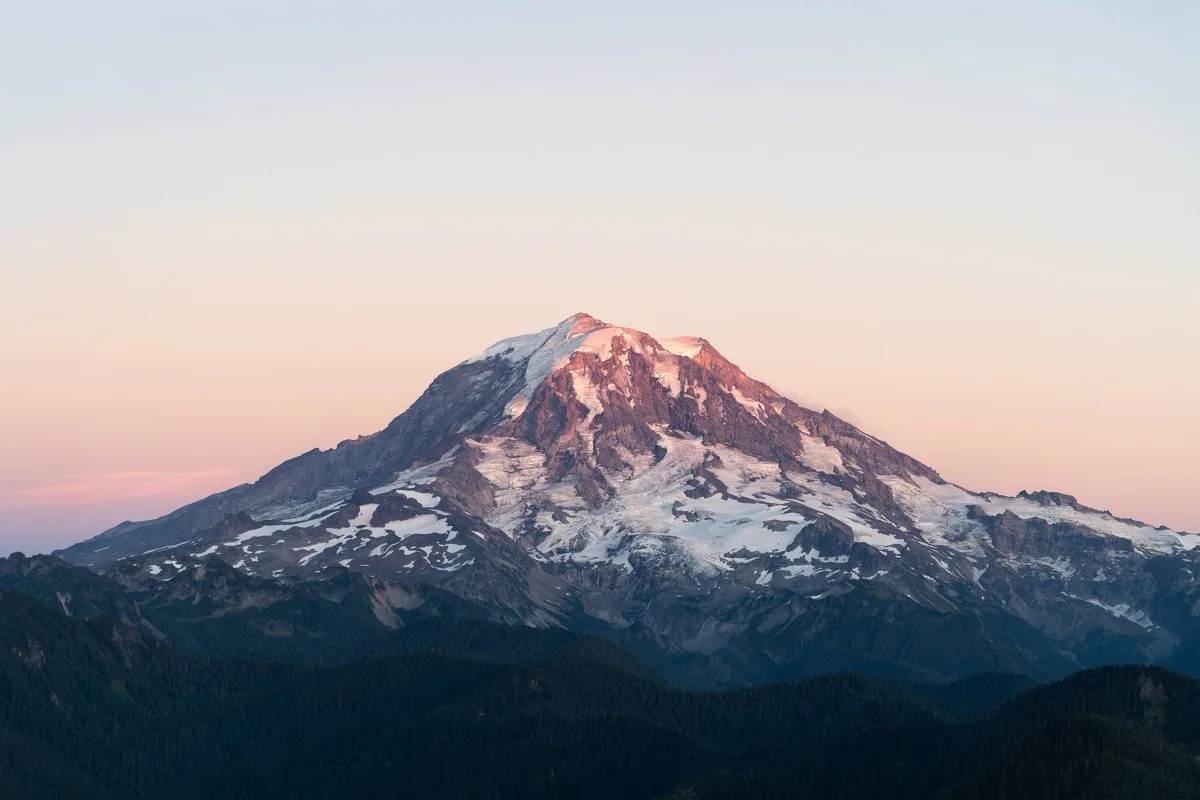
Mount Rainier, WA
2.5 hours south of Seattle — on the way
Mount Rainier is the kind of mountain that seems too large to be real. It rises alone from the surrounding hills — not as part of a range, just alone — 14,411 feet of glacier-draped volcano visible from a hundred miles away on a clear day. The drive up to Paradise goes through forest and then through subalpine meadow and then into a world that looks like it belongs to another latitude entirely.
Rainier is the most heavily glaciated peak in the contiguous United States — 25 active glaciers covering 35 square miles. Paradise Visitor Center sits at 5,400 feet with the glacier above it and wildflower meadows below it. In July and August, the meadows around Paradise are carpeted in lupine, paintbrush, and avalanche lilies in a display that is among the most extraordinary natural things in North America.
★ The moment
Stepping out of the car at Paradise at 5,400 feet and looking up at 9,000 feet of glacier directly above you, and then looking down at subalpine meadows full of wildflowers in every direction. The contrast — ice above, flowers below, nothing but blue sky — is almost too much.
⚠ Classic mistake
Staying in the parking lot. The meadow walks around Paradise are mostly flat, completely paved or well-marked, and take 30–60 minutes. Walking even a short distance into the meadows at sunrise, before the day visitors arrive, is a completely different experience from the parking lot.
📷 The photograph
Myrtle Falls, facing northwest — the falls frame on the left side of the image and Mount Rainier fills the sky behind and above them. This is the most reproduced photograph in the park. Take it anyway.
⏱ How long do you need?
2 hours: Paradise parking area + short Skyline Trail loop (1.2 miles, paved). Half day: add Myrtle Falls (easy 1-mile out-and-back, waterfall with Rainier behind it — one of the most photographed views in the park). Full day: add Reflection Lakes on the way in or out.
💬 What to ask
Ask a ranger at Paradise what it means that Rainier is a 'Decade Volcano.' The answer — that it's considered one of the most dangerous volcanoes on Earth because of the lahars that would race down its valleys toward cities in an eruption — is sobering and fascinating simultaneously.
Skip it if
It's a heavily overcast day and the mountain isn't visible. Rainier is cloud-covered frequently. The meadows are still beautiful, but the experience is different.
Don’t skip it if
It's a clear day. On a clear day, this is among the great experiences in North America.
Entry fee
$30/vehicle (7-day pass).
Gas
No gas inside the park. Fill in Ashford before entering.
Don't miss eating
Huckleberry milkshake at the National Park Inn or Paradise Inn — Pacific Northwest huckleberries are a regional treasure unavailable almost everywhere else.
Website
nps.gov/mora
This season
Spring / Summer
July and August: peak wildflower season at Paradise. The meadows are extraordinary. Come before 9am if possible.
Summer / Fall
September brings gold larch trees against white glaciers and blue sky — extraordinary color combination with almost no crowds.
Fall / Winter
Paradise is famous for snowshoeing in winter. Paradise Inn closes but roads usually stay open. Snowshoe rentals available.
Winter / Spring
Paradise averages 53 feet of snowfall annually. The record snowpack year buried the visitor center to the eaves. Check conditions carefully.
Average weather, all twelve months
| Jan | Feb | Mar | Apr | May | Jun | Jul | Aug | Sep | Oct | Nov | Dec | |
|---|---|---|---|---|---|---|---|---|---|---|---|---|
| High | 36° | 39° | 43° | 50° | 58° | 65° | 73° | 74° | 67° | 56° | 44° | 38° |
| Low | 26° | 27° | 30° | 35° | 41° | 47° | 53° | 54° | 49° | 41° | 33° | 28° |
| Rain | 7.0" | 5.5" | 6.5" | 4.5" | 3.5" | 2.5" | 1.0" | 1.2" | 2.8" | 5.0" | 8.0" | 8.5" |
Other options nearby
Things to do
Mount Rainier National Park
4.9★National Park
236,000-acre wilderness around Washington's highest peak encompassing wildflower meadows & glaciers.
Myrtle Falls
4.8★Tourist Attraction
Waterfall tumbling 72 ft. into a rugged gorge, with snow-capped Mount Rainier in the background.
Reflection Lake
4.8★Landmark
Naches Peak Loop Trailhead
4.8★Hiking Area
Short, looped hiking trail with views of lakes & Mount Rainier, plus wildflowers like blue lupine.
Mount Fremont Lookout Trail
4.9★Hiking Area
This 5.6-mile out-&-back hike with valley views follows a rocky ridge to a 1930s fire lookout.
Food & drink
Copper Creek Inn Restaurant & Lodging
4.5★Restaurant
Laid-back property offering country-style rooms, American dining & rustic cabins with kitchens.
Wildberry Restaurant
4.5★Restaurant
Homey restaurant with a large patio open seasonally for Sherpa-Himalayan dishes, burgers & pies.
Ukrainian Cuisine restaurant
4.2★Ukrainian Restaurant
Packwood Brewing Co.
4.4★Brewery
Rainier BaseCamp Bar & Grill
4.3★Bar & Grill
The Stops
Return · Northern Route
Stop 1
Olympic National Park, WA
West of Seattle — loop before heading east
Olympic is three completely different worlds in one park and the rainforest world is the one that catches people off guard. The Hoh Rain Forest doesn't feel like the United States. It feels ancient and northern European — 300-year-old Sitka spruce draped in curtains of club moss, total silence except for the river, and a green so deep and uniform it seems artificial.
Olympic contains glacier-capped peaks, the only temperate rainforest in the Lower 48, and 73 miles of wild Pacific coastline — all within one national park. The Hoh Rain Forest receives 140 inches of rain per year and contains trees that were growing when Columbus sailed. Ruby Beach on the Pacific side has sea stacks rising from the surf and tide pools full of starfish. These are not the same park.
★ The moment
Walking the Hall of Mosses trail in the Hoh Rain Forest — a half-mile loop under maples so draped in club moss that the light turns green. The silence here is specific and complete. It's one of the most otherworldly places in the United States.
⚠ Classic mistake
Only doing one of Olympic's three ecosystems. If you go, do the rainforest AND the coast. They're 40 minutes apart and feel like different continents.
📷 The photograph
Hall of Mosses trail: look for the big-leaf maple at the bend in the trail where the moss curtains are thickest and the light filters green from above. Morning light on an overcast day produces the most ethereal effect.
⏱ How long do you need?
Half day: Hoh Rain Forest Hall of Mosses trail (30 min) + Ruby Beach at low tide. Full day: add Hurricane Ridge for the mountain ecosystem and views toward the Strait of Juan de Fuca.
💬 What to ask
Ask a ranger at the Hoh Visitor Center about the 'One Square Inch of Silence' project — a spot deep in the park designated as one of the quietest places in the United States, and what it measures when jets fly over. The numbers are startling.
Skip it if
You only have a few hours. Olympic rewards time. A rushed visit to the rainforest misses what makes it extraordinary.
Don’t skip it if
You want to walk somewhere that feels genuinely primeval and unhurried.
Entry fee
$30/vehicle (7-day pass).
Gas
Port Angeles and Forks have gas. Very limited inside the park.
Don't miss eating
Clam chowder in a sourdough bread bowl at any restaurant in Port Angeles — if seafood works, this is the Pacific Northwest at its most iconic. If not, the First Street Haven in Port Angeles does exceptional vegetarian breakfast and lunch, beloved by locals, and is the kind of place you'd never find without someone telling you.
Website
nps.gov/olym
This season
Spring / Summer
Hoh Rain Forest is emerald green in spring. Hurricane Ridge wildflowers peak in July. Book Lake Quinault Lodge early.
Summer / Fall
September is the least rainy month in the rainforest — beautiful and still deeply green. Ruby Beach at low tide in October light is extraordinary.
Fall / Winter
The rainforest in its rainy season (November–February) is atmospheric in the most specific way — moss glows, the river runs high, and you'll have it almost to yourself.
Winter / Spring
January in the Hoh — fog, silence, old-growth forest, no other visitors. One of the most profound quiet experiences on this entire route.
Average weather, all twelve months
| Jan | Feb | Mar | Apr | May | Jun | Jul | Aug | Sep | Oct | Nov | Dec | |
|---|---|---|---|---|---|---|---|---|---|---|---|---|
| High | 46° | 49° | 53° | 58° | 64° | 69° | 74° | 74° | 68° | 58° | 50° | 46° |
| Low | 33° | 34° | 37° | 40° | 45° | 49° | 53° | 53° | 49° | 43° | 37° | 33° |
| Rain | 14" | 9" | 8" | 5" | 3" | 2" | 1" | 2" | 4" | 9" | 15" | 14" |
Other options nearby
Things to do
Hoh Rain Forest
4.7★National Park
Complex with visitor info, maps, rainforest exhibits & 2 of Hoh's popular nature trails nearby.
Sol Duc Falls
4.8★Park
Tumbling falls beneath wooden bridge at end of 1-mi. Sol Duc Falls Trail in old-growth forest.
Hall of Mosses Trailhead
4.8★Hiking Area
Lush, atmospheric forest of moss-covered trees & ferns along 0.8-mile loop trail in Hoh Rain Forest.
Marymere Falls Trailhead
4.8★Hiking Area
Easy 1.8-mile trail through old-growth forest to 2 vista points overlooking a 90-ft waterfall.
Sol Duc Trailhead
4.8★Hiking Area
Food & drink
Hard Rain Cafe
4.5★Cafe
Singer's Table
4.3★American Restaurant
The Springs Restaurant at Sol Duc Hot Springs
3.9★Restaurant
Stop 2
Columbia River Gorge, OR/WA
On I-84 — drive it; don't skip it
The Columbia River Gorge appears suddenly as you come off the plateau — a great cut in the earth with the river running brown and enormous below and basalt cliffs rising on both sides. Oregon is on the south side; Washington is on the north. The Historic Columbia River Highway on the Oregon side is a stone road from 1915 that clings to the cliff face and passes under 77 waterfalls.
The Columbia River carved this 80-mile gorge through the Cascade Mountains and left 77 waterfalls on the Oregon side alone. Multnomah Falls drops 620 feet in two tiers. Crown Point Vista House, a 1917 observation building on a basalt promontory, looks 30 miles down the gorge. The Historic Highway itself is an engineering marvel built before power tools.
★ The moment
Standing at the base of Multnomah Falls when the water is high in spring and feeling the mist from 620 feet of falling water from 100 feet away. The roar is constant and the spray coats everything. It's one of the most physically immersive natural experiences on the route.
⚠ Classic mistake
Driving I-84 through the gorge without taking the Historic Columbia River Highway exit. The interstate misses everything. Even a 30-minute detour onto the old highway — just Crown Point and Multnomah Falls — transforms the stop.
📷 The photograph
Multnomah Falls from the bridge — the stone footbridge halfway up the falls, with the upper falls above you and the lower falls below. This is the postcard image and it's a postcard for good reasons.
⏱ How long do you need?
1 hour: Multnomah Falls + Latourell Falls. Half day: full Historic Highway loop with Crown Point, all the waterfall pullouts, and lunch in Hood River. Full day: add the Washington side of the gorge and the town of White Salmon for the afternoon.
💬 What to ask
At Crown Point Vista House, ask someone about the Vista House itself — it was built in 1917 specifically as a rest stop for early motorists, and it has no structural steel. The entire dome and walls are hand-laid stone. That information makes you look at it differently.
Skip it if
You have previously driven the Historic Columbia River Highway.
Don’t skip it if
You haven't. And you like waterfalls.
Entry fee
Multnomah Falls parking requires timed reservation (free) May–October. Falls viewpoint is always free.
Gas
Abundant along I-84 through the gorge.
Don't miss eating
Fresh fruit pie at the Multnomah Falls Lodge restaurant — the Columbia River Gorge is surrounded by the most productive fruit-growing region in the Pacific Northwest, and the pies made from Hood River cherries, pears, and apples are extraordinary. Hood River town itself has excellent vegetarian options at Boda's Kitchen.
Website
gorgefriends.org
This season
Spring / Summer
April and May are peak waterfall season — snowmelt makes every fall thunderous. Multnomah in summer crowds: arrive before 8am.
Summer / Fall
September and October bring gold and crimson leaves against the basalt cliffs — the Historic Highway at peak fall color is breathtaking.
Fall / Winter
October and November produce some of the most dramatic photography in the Pacific Northwest. Ice occasionally forms on the falls in December.
Winter / Spring
January waterfalls are thundering from winter rain. Fewer crowds than any other time of year.
Average weather, all twelve months
| Jan | Feb | Mar | Apr | May | Jun | Jul | Aug | Sep | Oct | Nov | Dec | |
|---|---|---|---|---|---|---|---|---|---|---|---|---|
| High | 43° | 48° | 55° | 62° | 69° | 76° | 84° | 83° | 74° | 62° | 50° | 43° |
| Low | 32° | 34° | 39° | 44° | 49° | 55° | 61° | 60° | 54° | 46° | 38° | 32° |
| Rain | 4.2" | 3.2" | 3.0" | 2.3" | 2.0" | 1.2" | 0.4" | 0.7" | 1.2" | 2.5" | 4.5" | 4.5" |
Other options nearby
Things to do
Vista House at Crown Point
4.8★Historical Landmark
Octagonal rest stop & observation point overlooking river & mountains, built in the early 1900s.
Beacon Rock State Park
4.8★State Park
Camping park with many miles of trails, including a climb up a massive rock with Gorge views.
Multnomah Falls
4.8★Tourist Attraction
Well-known, dramatic cascade with a visitor's center, observation platform & hiking trails.
Wahkeena Falls
4.8★Tourist Attraction
This 242-ft. waterfall along the Historic Columbia River Highway can be crossed via a hiking trail.
Eagle Creek Trailhead
4.7★Hiking Area
Food & drink
Sugarpine Drive-In
4.5★Restaurant
Drive-through eatery with a walk-up window & outdoor seats, serving soft serve, salads & sandwiches.
Troutdale Station Food Carts
4.5★Food Court
Chick-fil-A
4.0★Fast Food Restaurant
Fast-food chain serving chicken sandwiches & nuggets along with salads & sides.
Multnomah Falls Lodge
4.5★American Restaurant
Locally inspired breakfast & lunch in a circa-1925 rock lodge with a patio & waterfall access.
Thunder Island Brewing Co
4.3★Brewery

Stop 3
Glacier National Park, MT
North of I-90 via US-2 — the full detour
Glacier is what the American West looked like before. The mountains here are sharp and young — still being carved, still glaciated, still dramatic in a way that the older, more eroded ranges of the South are not. The Going-to-the-Sun Road climbs from a valley floor at 3,000 feet to a ridge at 6,646 feet in 32 miles, and the scenery escalates with every mile. Grizzly bears cross the road in front of you. Mountain goats walk on cliffs that should be impossible.
Going-to-the-Sun Road is one of the great engineering achievements of the American National Park System and one of the great scenic drives on Earth — a 50-mile road crossing the Continental Divide that was carved by hand into the face of a mountain between 1921 and 1932. The park has 130 named lakes, 25 remaining glaciers, and 700 miles of trails. Wildlife is abundant and visible.
★ The moment
Cresting Logan Pass at 6,646 feet on Going-to-the-Sun Road and stepping out of the car to see the Garden Wall — a razor-sharp glacially carved ridge extending miles in both directions, with turquoise lakes 3,000 feet below and glaciers clinging to the faces above you. This is the view people talk about for the rest of their lives.
⚠ Classic mistake
Driving Going-to-the-Sun Road in the west-to-east direction. Drive east to west: the most dramatic sections — the cliff-hanging section above the Garden Wall, the views down into the Lake McDonald Valley — are better in that direction, and you'll be on the mountain side rather than the cliff-edge side of the road.
📷 The photograph
The Going-to-the-Sun Road view from the 'Weeping Wall' section — the road carved into the cliff face with a thin waterfall running directly across it. From this angle, the scale of the road against the mountain becomes visible.
⏱ How long do you need?
Half day: Going-to-the-Sun Road full drive (2.5–3 hours without stops, 4–5 with). Full day: add a Logan Pass boardwalk walk (mountain goats are commonly seen right from the boardwalk) and Hidden Lake overlook (1.5 miles from Logan Pass).
💬 What to ask
Ask a ranger at Logan Pass about the pace of glacial retreat in the park. In 1850 there were 150 named glaciers. There are now 25. The comparison photos — same location, 1913 and today — are on display at the Logan Pass Visitor Center and are among the most clarifying images of climate change that exist.
Skip it if
Going-to-the-Sun Road is not yet open for the season (typically mid-June) or timed vehicle reservations are full.
Don’t skip it if
You want to drive something that will make you feel small in the best possible way.
Entry fee
$35/vehicle (7-day pass). Going-to-the-Sun Road vehicle reservations required May–September — book at recreation.gov.
Gas
Fill in Whitefish or Kalispell before entering. Limited inside the park.
Don't miss eating
Huckleberry pie at any restaurant in Whitefish or at the Belton Chalet near the west park entrance. Montana huckleberries are a state treasure.
Website
nps.gov/glac
This season
Spring / Summer
Going-to-the-Sun Road opens mid-June typically. Drive east to west for the best views. Reserve vehicle entry at recreation.gov.
Summer / Fall
September is arguably the finest month — fall colors, almost no crowds, and every facility still open. Wildlife sightings are common.
Fall / Winter
Road closes mid-October. Limited west-side access remains. The mountains in autumn snow are extraordinary.
Winter / Spring
The towns of Whitefish and Kalispell are lovely in late spring. The park proper is still snowbound until June.
Average weather, all twelve months
| Jan | Feb | Mar | Apr | May | Jun | Jul | Aug | Sep | Oct | Nov | Dec | |
|---|---|---|---|---|---|---|---|---|---|---|---|---|
| High | 30° | 36° | 44° | 54° | 64° | 72° | 82° | 81° | 69° | 55° | 39° | 31° |
| Low | 13° | 17° | 23° | 31° | 39° | 47° | 52° | 51° | 43° | 33° | 23° | 15° |
| Rain | 3.5" | 2.5" | 2.5" | 2.0" | 2.5" | 2.8" | 1.5" | 1.5" | 2.0" | 2.5" | 3.5" | 3.5" |
Other options nearby
Things to do
Glacier National Park
4.8★National Park
More than 700 miles of trails in a vast park with diverse landscapes & abundant wildlife.
Trail of the Cedars Nature Trailhead
4.8★Hiking Area
Scenic 1-mi. loop trail, a favorite for towering red cedars, lush ferns & easy accessibility.
Avalanche Lake Trailhead
4.9★Hiking Area
Moderate 5-mile round-trip trail leading through the forest to a picturesque mountain lake.
Saint Mary Falls
4.9★Tourist Attraction
Scenic 35-ft. waterfall in Glacier National Park, accessible via a moderate hiking trail.
Jackson Glacier Overlook
4.8★Tourist Attraction
Going-to-the-Sun Road pullout with views of Jackson Glacier, Glacier National Park's 7th largest.
Food & drink
Two Dog Flats Restaurant
4.1★American Restaurant
Rising Sun Pizza
4.3★Pizza Restaurant
Kip's Beer Garden
4.1★Bar & Grill
Park Cafe & Grocery
4.1★Restaurant
Casual American spot offering burgers, breakfast, homemade pies & souvenirs in a down-home setting.
Frog's Cantina
3.7★Mexican Restaurant
Stop 4
Badlands National Park, SD
On I-90 — pull off
The Badlands appear without warning. You're driving across flat South Dakota prairie and then the earth breaks open — spires, buttes, gullies, and formations painted in ochre, cream, and lavender stretching to the horizon. It looks like a different planet. Bison walk through it. Prairie dogs bark from their towns beside the road. There is nothing else in America like it.
The Badlands were deposited layer by layer over 75 million years and exposed by erosion over the last 500,000 years. Bison herds roam freely through the park — the largest bison herd in the national park system. The 244,000-acre park contains some of the richest fossil beds in the world. And Wall Drug, just west of the park entrance, has been promising free ice water on billboards every 5 miles for 500 miles. You owe it to yourself to cash that in.
★ The moment
Watching a bison herd move slowly across the formations at dusk — 200 animals navigating between the painted spires as the sky turns amber and the shadows deepen. Pure, unchanged American West.
⚠ Classic mistake
Driving through on the interstate and only stopping at the Wall Drug exit. The park loop road takes 45 minutes even without stopping and shows you the full scale of what's here. Wall Drug is 20 minutes on top of that. Do both.
📷 The photograph
The Big Badlands Overlook at sunrise — the formations in the foreground, the prairie extending to the horizon, the sky enormous above everything. The low morning light turns the formations deep orange.
⏱ How long do you need?
1 hour: drive the Badlands Loop Road (SD-240) with 3–4 pullouts. 2 hours: loop + short walk at Door/Window/Notch trails. Half day: add Wall Drug and the Ben Reifel Visitor Center for the fossil displays.
💬 What to ask
At Wall Drug, ask how many billboards they actually have. The answer is 351, extending through several states. Ask them to explain the free ice water promotion — it started in 1936 and essentially invented the roadside billboard attraction as we know it.
Skip it if
You've already seen the Grand Canyon and the Painted Desert and geological formations are genuinely saturating you.
Don’t skip it if
You haven't seen bison in the wild. You will here, close, from the car.
Entry fee
$30/vehicle (7-day pass).
Gas
Wall, SD just off I-90 at the park exit.
Don't miss eating
Homemade pie at Wall Drug — the apple and peach pies have been made from scratch since the 1930s and are genuinely excellent. Pair with their famous 5-cent coffee. It is exactly the right thing to eat in exactly this place.
Website
nps.gov/badl
This season
Spring / Summer
May and June: bison calves, wildflowers in the mixed-grass prairie, sunrises that will restructure how you see color.
Summer / Fall
September is the best month — cooler, quieter, golden light on the formations that makes every photograph look like a painting.
Fall / Winter
October snow on the orange formations produces extraordinary images. Services reduce significantly by November.
Winter / Spring
January is brutally cold but the park is nearly empty. The formations in snow look like something painted.
Average weather, all twelve months
| Jan | Feb | Mar | Apr | May | Jun | Jul | Aug | Sep | Oct | Nov | Dec | |
|---|---|---|---|---|---|---|---|---|---|---|---|---|
| High | 35° | 40° | 50° | 63° | 73° | 83° | 92° | 90° | 79° | 65° | 48° | 37° |
| Low | 11° | 17° | 26° | 37° | 47° | 57° | 63° | 61° | 50° | 37° | 24° | 13° |
| Rain | 0.4" | 0.5" | 0.8" | 1.4" | 2.4" | 2.8" | 2.0" | 1.6" | 1.3" | 1.0" | 0.5" | 0.4" |
Other options nearby
Things to do
Badlands National Park
4.9★National Park
244,000 rugged acres of geological formations, prairie grass & wildlife like bison & bighorn sheep.
Wall Drug Store
4.2★Drug Store
A drug store, gift shop & eateries are some of the amenities on hand at this 76,000-sq.-ft. sight.
Pinnacles Overlook
4.9★Scenic Spot
Popular stop with sweeping views of the Badlands' jagged natural formations & wildlife.
Delta-09 Minuteman Missile Silo
4.7★Historical Landmark
Roberts Prairie Dog Town
4.7★Scenic Spot
Section of Badlands, reached via a dirt road, teeming with vocal, uninhibited wild prairie dogs.
Food & drink
Wall Drug Store
4.2★Drug Store
A drug store, gift shop & eateries are some of the amenities on hand at this 76,000-sq.-ft. sight.
Salty Steer
4.3★Restaurant
Badlands Saloon & Grille
3.9★Bar & Grill
Down-to-earth neighborhood tavern supplying beer, pizza, burgers & other familiar pub fare.
Red Rock
3.9★Restaurant
Dairy Queen Grill & Chill
3.9★Fast Food Restaurant
Soft-serve ice cream & signature shakes top the menu at this classic burger & fries fast-food chain.
Stop 5
Mount Rushmore & Crazy Horse Memorial, SD
45 min south of I-90 via US-16
Rushmore is larger than the photographs suggest and smaller than the idea of it. You recognize the faces immediately and then spend a while reckoning with the scale and the strange fact of it — four presidents' faces carved into granite in the Black Hills. Crazy Horse, a few miles down the road, is completely different: still being carved after 75 years, enormous beyond comprehension, and telling a story that reframes everything you just saw at Rushmore.
Mount Rushmore was carved between 1927 and 1941 by sculptor Gutzon Borglum and 400 workers. The faces are 60 feet tall. The Crazy Horse Memorial, begun in 1948 by Korczak Ziolkowski and continued by his family after his death, will depict the Lakota leader on horseback at a scale 10 times larger than Rushmore. After 75 years, the face is complete. The rest of the mountain is still being carved. Visiting both together creates one of the most complex and honest American experiences available anywhere.
★ The moment
Standing in front of Crazy Horse at the evening laser light show and looking up at the completed face — 87 feet tall — and then at the scale model showing what the finished sculpture will look like, and grasping that this family has spent 75 years on this work and may spend another 75 before it's finished.
⚠ Classic mistake
Skipping Crazy Horse because you've seen Rushmore. They are 17 miles apart and utterly different in meaning. Rushmore without Crazy Horse is half a conversation.
📷 The photograph
Rushmore: from the Grand View Terrace along the Avenue of Flags — the flags frame the carving and add scale. Crazy Horse: from the viewing platform at the museum, the completed face fills the frame with the mountain below still raw.
⏱ How long do you need?
1 hour: Rushmore alone. 2 hours: Rushmore + Crazy Horse. Half day: add the evening lighting ceremony at Rushmore (summer) and the laser show at Crazy Horse.
💬 What to ask
At Crazy Horse, ask one of the Ziolkowski family members — they work the memorial — how much of the mountain has been removed so far. The answer (8 million tons) and the answer to what percentage of the sculpture is complete (less than 10%) are both staggering.
Skip it if
You are severely pressed for time and have to choose: choose Crazy Horse. It's the less-known and more affecting of the two.
Don’t skip it if
You want to understand something true and complicated about America. Both of these places are necessary for that.
Entry fee
Rushmore: free. Crazy Horse: ~$15/person.
Gas
Keystone and Hill City nearby.
Don't miss eating
Huckleberry ice cream and fresh-baked goods at the Mount Rushmore Lodge bakery or any shop in Keystone — the Black Hills huckleberry is the same variety as Glacier's and equally extraordinary. Sylvan Lake Lodge inside Custer State Park does an excellent vegetarian menu in a stunning setting.
Website
nps.gov/moru and crazyhorsememorial.org
This season
Spring / Summer
Evening lighting ceremony at Rushmore (Memorial Day through Labor Day) is worth staying for. Crazy Horse laser show on summer evenings.
Summer / Fall
September crowds drop sharply after Labor Day. October light on the granite is exceptional.
Fall / Winter
Both are open year-round. The sculptures in snow are dramatic and visitors are almost nonexistent.
Winter / Spring
February visits are quiet and moving. Both sites are accessible year-round.
Average weather, all twelve months
| Jan | Feb | Mar | Apr | May | Jun | Jul | Aug | Sep | Oct | Nov | Dec | |
|---|---|---|---|---|---|---|---|---|---|---|---|---|
| High | 35° | 40° | 48° | 59° | 69° | 79° | 87° | 85° | 75° | 62° | 47° | 37° |
| Low | 11° | 16° | 24° | 34° | 44° | 53° | 59° | 57° | 47° | 35° | 23° | 13° |
| Rain | 0.5" | 0.6" | 1.0" | 1.7" | 2.6" | 2.9" | 1.9" | 1.5" | 1.3" | 1.0" | 0.6" | 0.5" |
Other options nearby
Things to do
Mount Rushmore National Memorial
4.7★Park
Massive mountainside sculpture drawing crowds for its depiction of 4 former American presidents.
Custer State Park
4.8★State Park
Huge nature preserve featuring scenic views, trails & resorts among the flora & fauna.
Crazy Horse Memorial
4.4★Monument
Started in 1948, this vast, unfinished mountain carving shares a site with a Native American museum.
Bear Country USA
4.7★Wildlife Park
Seasonal drive-through wildlife park with wolves, bears, elk & other North American animals.
Reptile Gardens
4.7★Zoo
Long-running zoo with many reptile exhibits, plus bird shows, giant tortoises & a greenhouse.
Food & drink
Mt. Rushmore Brewing Company
4.2★Restaurant
Easygoing taproom/brewpub offering house & guest craft beers, elevated pub fare & deck seating.
Big Thunder Gold Mine
4.4★Tourist Attraction
Mining museum in a replica 1895 gold mill, guided tours of an old goldmine, plus gold & gem panning.
The Custer Wolf - Food & Drink
4.6★American Restaurant
Warm, casual outlet serving hearty American pub grub & sandwiches alongside on-tap beers.
Fort Hays Chuckwagon Supper & Show
4.6★Restaurant
Meat-&-potato meals are served in a down-home space followed by a Wild West-themed variety show.
Ruby House Restaurant
4.2★American Restaurant
Relaxed institution serving hearty American fare in a multilevel space with an Old West theme.
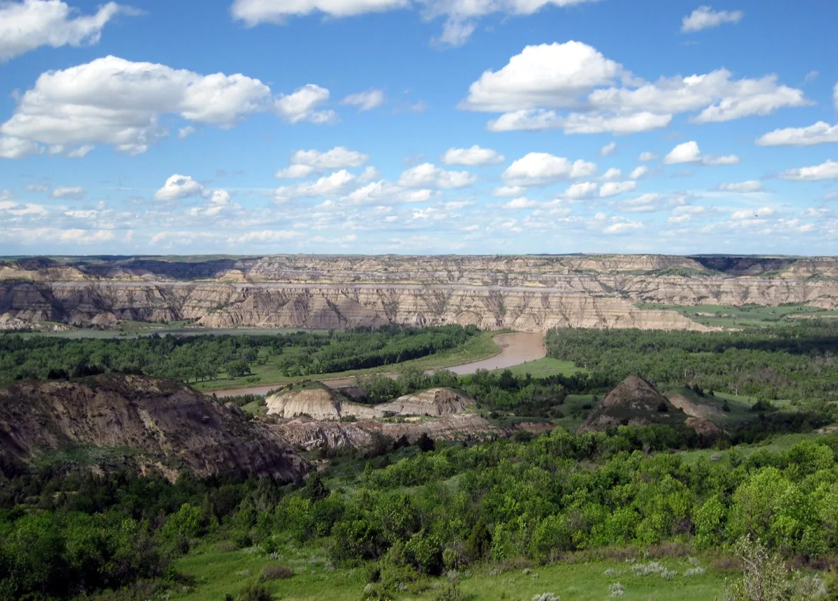
Stop 6
Theodore Roosevelt National Park, ND
On I-94
Theodore Roosevelt National Park is the most underrated park in the United States and it is not close. You expect flat North Dakota. You get painted badlands identical to South Dakota's but completely empty of other people, wild horses galloping across the formations, and a bison bull grazing 30 feet from your car window with total indifference. This is the American West that has been forgotten.
Roosevelt came here in 1883 to hunt bison and stayed — eventually owning two ranches in what is now the park. He lost his wife and mother on the same day in 1884 and returned here to grieve. The experience shaped the conservation ethic that made him the president who established 230 million acres of protected land. The park preserves his original Elkhorn Ranch site and contains bison, wild horses, elk, pronghorn, and longhorn cattle against some of the most beautiful badland scenery in the country.
★ The moment
Watching a band of wild horses — genuine, federally protected feral horses — canter across the painted formations at sunset with no fence, no handler, and no one else watching. This is the American West unchanged.
⚠ Classic mistake
Treating this as a rest stop and not stopping at all. The Scenic Loop Drive in the South Unit is 36 miles and takes 90 minutes. The wildlife density on this road is extraordinary. Pull over for the prairie dog towns — they bark and perform and are genuinely entertaining.
📷 The photograph
Wind Canyon overlook — a short quarter-mile trail from the Scenic Loop — where the Little Missouri River curves below a badland ridge and the entire South Unit spreads to the horizon. Sunset from here.
⏱ How long do you need?
90 minutes: South Unit Scenic Loop Drive. Half day: Scenic Loop + Painted Canyon Visitor Center + prairie dog town. Full day: add the North Unit (separate entrance, 70 miles north, even more dramatic badlands).
💬 What to ask
Ask a ranger about Roosevelt's transformation in this landscape — specifically about what he wrote in his diary the night his wife and mother died on the same day, and what the badlands gave him. It's one of the great American stories of grief and renewal.
Skip it if
You've just left the Badlands and are genuinely badland-saturated. (Though this park is noticeably less crowded and the wildlife density is higher.)
Don’t skip it if
You haven't seen wild horses in the wild. You will here, commonly, from the road.
Entry fee
$30/vehicle (7-day pass).
Gas
Medora, just outside the park entrance, has gas.
Don't miss eating
Chokecherry jam on fresh bread at any café in Medora — chokecherries grow wild throughout the North Dakota badlands and the local jam is something you genuinely cannot find elsewhere. The Medora Musical outdoor dinner includes vegetarian options and the setting — eating outside surrounded by the badlands at dusk — is worth it regardless of the menu.
Website
nps.gov/thro
This season
Spring / Summer
May: bison calves, wildflowers. Sunset Scenic Loop in June — golden light on the formations with bison in the foreground.
Summer / Fall
September: fall cottonwood colors along the Little Missouri River. Bison rut in late August is thrilling to witness safely from your car.
Fall / Winter
October and November are cold but the park stays open. Bison in their winter coats. Hardy and beautiful.
Winter / Spring
January and February are very cold. Call ahead for road conditions.
Average weather, all twelve months
| Jan | Feb | Mar | Apr | May | Jun | Jul | Aug | Sep | Oct | Nov | Dec | |
|---|---|---|---|---|---|---|---|---|---|---|---|---|
| High | 27° | 34° | 46° | 60° | 71° | 80° | 88° | 87° | 75° | 61° | 43° | 30° |
| Low | 6° | 12° | 23° | 35° | 46° | 55° | 61° | 59° | 48° | 36° | 22° | 9° |
| Rain | 0.5" | 0.4" | 0.8" | 1.3" | 2.0" | 2.5" | 1.8" | 1.5" | 1.2" | 0.9" | 0.5" | 0.4" |
Other options nearby
Things to do
Theodore Roosevelt National Park
4.8★National Park
Bison, elk & deer roam this scenic park of prairie & rugged badlands marked by stunning buttes.
Badlands Overlook
4.9★Scenic Spot
Bully Pulpit Golf Course
4.7★Golf Course
Rough Rider State Park
4.5★Park
Petrified Forest Loop
4.6★Hiking Area
Food & drink
Little Missouri Saloon & Dining Room
4.3★Bar & Grill
Pitchfork Steak Fondue
4.3★Steak House
Boots Bar & Grill
4.2★Bar & Grill
Mellow spot offering steaks, burgers & other basics, plus brews & wines in homey digs with a patio.
Farmhouse Cafe
4.5★American Restaurant
Hidden Springs Java
4.8★Coffee Shop
Stop 7
Mackinac Island, MI
~2 hours north of I-75
You step off the ferry and the first thing you notice is the absence of engine noise. No cars. No motorcycles. Just horse hooves on brick streets, the smell of fudge coming from six different shops simultaneously, and Victorian hotels in white and yellow with their flags snapping in the lake wind. The 19th century is still present on Mackinac Island in a way that isn't nostalgic — it's just how it is.
Mackinac Island prohibited automobiles in 1898 and has maintained the ban ever since. The island is 3.8 miles around, traversed by horse-drawn carriage, bicycle, or foot. The Grand Hotel's front porch is 660 feet long — the longest in the world — and the hotel has been operating since 1887. The island has made fudge for over 150 years and the scent when you step off the ferry is its own category of experience.
★ The moment
Renting a bicycle and riding the perimeter of the island — 8 miles of road with Lake Huron on one side and Victorian summer cottages on the other, the Mackinac Bridge visible in the distance, no cars anywhere, and the smell of fudge following you all the way around.
⚠ Classic mistake
Only going to the fudge shops and the Grand Hotel porch. Walk up to Fort Mackinac — the fully preserved 1780 British fort on the bluff above the town. The view from the fort walls down to the Straits of Mackinac and the 5-mile-long Mackinac Bridge is one of the finest in the Great Lakes.
📷 The photograph
The view from the Fort Mackinac walls looking north over the town and the Straits of Mackinac — the Grand Hotel porch is visible below, the bridge in the distance, and the blue of Lake Huron filling the horizon.
⏱ How long do you need?
3 hours: town + Grand Hotel porch + Fort Mackinac. Full day: add the perimeter bicycle ride and a long lunch.
💬 What to ask
Ask at the Grand Hotel about the 1980 film 'Somewhere in Time' — it was filmed entirely at the Grand Hotel and has created a devoted following that visits the island specifically because of it. The hotel leans into this beautifully.
Skip it if
The ferry is not running (mid-November through April).
Don’t skip it if
Either of you wants to spend a few hours somewhere that has genuinely not changed in 125 years.
Entry fee
Ferry: ~$28 roundtrip/person from Mackinaw City. Fort Mackinac: ~$15/adult.
Gas
No cars on the island. Ferry from Mackinaw City or St. Ignace.
Don't miss eating
Fresh warm fudge from Murdick's Fudge — the original Mackinac Island fudge shop since 1887. Buy it immediately after stepping off the ferry. Eat it while walking.
Website
mackinacisland.org
This season
Spring / Summer
May and June: lilacs bloom all over the island — the Lilac Festival in June is beloved. Ferry service begins mid-May.
Summer / Fall
September is perfect — summer crowds gone, leaves turning gold, horse-drawn carriage rides peaceful.
Fall / Winter
Island closes to ferries by mid-November. Do not plan a winter visit.
Winter / Spring
Plan May through October only.
Average weather, all twelve months
| Jan | Feb | Mar | Apr | May | Jun | Jul | Aug | Sep | Oct | Nov | Dec | |
|---|---|---|---|---|---|---|---|---|---|---|---|---|
| High | 27° | 30° | 40° | 54° | 65° | 74° | 80° | 78° | 70° | 57° | 43° | 31° |
| Low | 13° | 15° | 24° | 35° | 45° | 54° | 61° | 60° | 52° | 41° | 30° | 18° |
| Rain | 1.8" | 1.3" | 1.8" | 2.3" | 2.8" | 3.0" | 3.0" | 3.4" | 3.4" | 3.0" | 2.7" | 2.1" |
Other options nearby
Things to do
Headlands International Dark Sky Park
4.8★Park
Bear, deer & eagles roam this 550-acre woodland with 2+ miles of undeveloped Lake Michigan beach.
Straits State Park
4.7★State Park
Waterfront beach park with many campsites, scenic bridge views, a picnic area & a playground.
Arch Rock
4.8★Scenic Spot
Limestone arch overlooking the lake & accessed by trails in an island state park.
St Ignace, MI
4.7★Tourist Attraction
Castle Rock
4.6★Tourist Attraction
Kitschy spot with a Paul Bunyan statue & stairs to the top of a limestone rock with lake views.
Food & drink
Kewadin Casinos – St. Ignace
3.9★Casino
Cards, slots & live Keno await at this lakeside casino with a buffet, sports bar & on-site hotel.
Darrow's Family Restaurant
4.6★Family Restaurant
Former drive-in now a revered local haunt for scratch-made homestyle fare & handmade pies.
Clyde's Drive-In
4.6★Hamburger Restaurant
Vintage drive-in burger joint known for 3/4-lb. burgers offers up fries, onion rings & shakes.
McDonald's
3.6★Fast Food Restaurant
Classic, long-running fast-food chain known for its burgers & fries.
Pink Pony
4.5★Bar & Grill
Pink-accented, nautical-themed restaurant in the Chippewa Hotel featuring American fare.
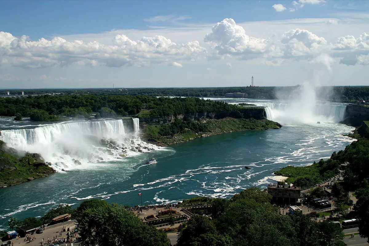
Stop 8
Niagara Falls, NY / Ontario
On the I-90 corridor
The falls are louder than you expect. That's the thing no photograph communicates — the sound arrives before the water is visible, a sustained roar that fills the air and vibrates in your chest. Then the mist. Then the sheer volume of water — six million cubic feet per minute — moving so fast and in such quantity that it doesn't look quite real. Your brain categorizes it as a movie. It is not a movie.
Niagara Falls is the most powerful waterfall in North America — 3,160 tons of water per second over the American and Horseshoe Falls combined. The Maid of the Mist boat has been taking passengers to the base of the falls since 1846. The Canadian side of the border — Horseshoe Falls — offers the full panoramic view that the American side cannot. It's worth crossing the border for 90 minutes to stand in front of the full sweep of the horseshoe.
★ The moment
On the Maid of the Mist, in the yellow poncho, as the boat pushes directly into the mist and roar at the base of Horseshoe Falls. The noise becomes all-encompassing. You cannot speak to the person next to you. The falls are 175 feet tall and 2,600 feet wide and they are directly in front of you. Nothing about this is subtle.
⚠ Classic mistake
Skipping the Canadian side to save the border crossing hassle. The American side shows you the falls from the side. The Canadian side shows you the full horseshoe from in front. They are fundamentally different views and the Canadian one is the one you came here for. Bring a passport.
📷 The photograph
From the Canadian side, at the curved overlook railing directly in front of Horseshoe Falls — full width of the falls in frame, the mist rising 300 feet, and the rainbow that forms in the mist on sunny mornings.
⏱ How long do you need?
2 hours: American side + Maid of the Mist (May–October). Half day: add the Canadian side via the Rainbow Bridge (walking is easy and free).
💬 What to ask
Ask anyone at the visitor center about the night of March 29, 1848, when the falls went completely silent — an ice jam in Lake Erie upstream blocked the flow entirely for 30 hours. People walked out on the exposed riverbed. Soldiers found old War of 1812 muskets and cannonballs. It has never happened again.
Skip it if
You've been before and the Maid of the Mist isn't running.
Don’t skip it if
This is your first time. It's one of the seven natural wonders of the world and it's on your route.
Entry fee
Maid of the Mist: ~$28/adult. Niagara State Park: free. Canadian side: bring passport, parking ~$25.
Gas
Abundant throughout Niagara.
Don't miss eating
Dinner in Lewiston, NY (20 min south of the falls) — a charming small town far from the tourist strip with genuinely good restaurants. Brickyard Pub for a real local meal.
Website
niagarafallsstatepark.com
This season
Spring / Summer
April and May: falls at peak power from snowmelt. Maid of the Mist runs May through October.
Summer / Fall
July is busy but the falls don't care about crowds. The experience overwhelms regardless. October foliage around the gorge is beautiful.
Fall / Winter
December and February: the falls partially freeze — a haunting spectacle. Maid of the Mist stops but illumination continues at night.
Winter / Spring
January ice formations on the cliffs surrounding the falls are extraordinary. Dress for extreme cold and spray.
Average weather, all twelve months
| Jan | Feb | Mar | Apr | May | Jun | Jul | Aug | Sep | Oct | Nov | Dec | |
|---|---|---|---|---|---|---|---|---|---|---|---|---|
| High | 31° | 33° | 42° | 55° | 66° | 76° | 81° | 79° | 72° | 60° | 48° | 35° |
| Low | 18° | 19° | 27° | 38° | 49° | 59° | 64° | 63° | 56° | 44° | 35° | 23° |
| Rain | 2.5" | 2.3" | 2.7" | 3.0" | 3.5" | 3.5" | 3.2" | 3.3" | 3.5" | 3.0" | 3.8" | 3.0" |
Other options nearby
Things to do
Niagara Falls
4.8★Nature Preserve
Famous, towering waterfalls at the boundary of Canada & the United States, with tours & boat rides.
Peace Bridge
4.3★Bridge
Picturesque, walkable & drivable bridge connecting the United States & Canada.
Fallsview Casino Resort
4.3★Casino
Refined rooms & suites in a hotel with falls views, plus an indoor pool, a casino & eclectic dining.
Journey Behind the Falls
4.5★Scenic Spot
Year-round site with Horseshoe Falls views from below & behind via tunnels & observation decks.
Niagara City Cruises
4.8★Tourist Attraction
Food & drink
Fallsview Casino Resort
4.3★Casino
Refined rooms & suites in a hotel with falls views, plus an indoor pool, a casino & eclectic dining.
Great Wolf Lodge | Niagara
4.4★Water Park
Laid-back suites in a lively property featuring a water park & a spa, plus 8 eateries & bars.
Fashion Outlets of Niagara Falls USA
4.4★Shopping Mall
Contemporary shopping mall with outlet stores from well-known retailers, plus restaurants & cafes.
Niagara Pen Centre
4.3★Shopping Mall
180 varied stores, casual dining options & a movie theater compose this enduring enclosed mall.
Skylon Tower
4.4★Tourist Attraction
Observation tower featuring sweeping vistas of Niagara Falls plus an arcade & revolving restaurant.
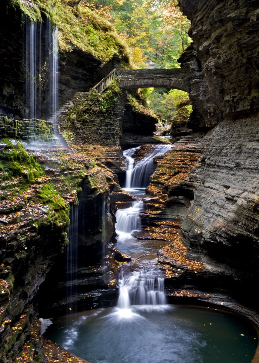
Stop 9
Finger Lakes & Watkins Glen, NY
~1 hour south of I-90
The Finger Lakes are what the South imagines when it imagines New York State — rolling green hills, long blue lakes, small towns with good coffee, and wineries on every hillside. Watkins Glen is the surprise: a gorge trail through a state park where you walk on stone steps carved into the gorge walls while 19 waterfalls cascade around and over you in 1.5 miles. It's free. Almost nobody outside the Northeast knows it exists.
Eleven long, narrow lakes carved by glaciers dominate this region of central New York. The Finger Lakes wine region produces some of the finest Riesling in the world — the climate, moderated by the lakes, is nearly identical to Germany's Mosel Valley. Watkins Glen State Park's gorge trail passes under waterfalls, through a tunnel carved from the gorge wall, and across stone bridges over the creek. It is one of the great short walks in the eastern United States.
★ The moment
Walking the Watkins Glen gorge trail from the bottom entrance, where the gorge walls close to 20 feet apart above you and the sound of the first waterfall fills the narrow stone canyon. The light goes green and the spray catches it.
⚠ Classic mistake
Skipping the gorge trail because it sounds like hiking. It is not hiking. It is a 1.5-mile walk on stone stairs and flat paths. The elevation gain is modest and the payoff is 19 waterfalls. The entire loop takes 90 minutes.
📷 The photograph
The 'Spiral Gorge' section of the Watkins Glen trail — where the stone path spirals upward through the gorge wall and you can photograph down through the spiral with water visible below and the gorge walls framing everything.
⏱ How long do you need?
90 minutes: Watkins Glen gorge trail. Half day: gorge trail + two or three winery visits. Full day: add Ithaca (Cornell campus gorges, Ithaca Falls, exceptional restaurants).
💬 What to ask
At any Finger Lakes winery tasting room, ask the pourers why the region produces such exceptional Riesling. The answer — the deep, narrow lakes act as heat sinks, moderating temperature extremes, mimicking exactly the conditions of the Mosel Valley — will make every sip of the wine mean more.
Skip it if
Watkins Glen gorge trail is closed for winter (typically November through April).
Don’t skip it if
You want one more extraordinary natural thing before you head home. This is it.
Entry fee
Watkins Glen State Park: ~$8/vehicle. Wineries vary, typically $5–15 for tasting.
Gas
Abundant throughout the region.
Don't miss eating
A Riesling tasting flight at any Finger Lakes winery — this is one of the great white wine regions in the world and a tasting here costs $10–15 and will surprise you. For food, the Moosewood Restaurant in Ithaca has been one of America's most celebrated vegetarian restaurants since 1973. It is not a detour. It is the meal.
Website
fingerlakes.com
This season
Spring / Summer
May and June: gorge wildflowers + wine trail opening. Ithaca Saturday Farmers Market is one of the best in New York.
Summer / Fall
October is peak season — foliage, harvest, and wineries all peaking simultaneously. One of the great fall drives in the East.
Fall / Winter
Many wineries remain open weekends in November. Gorge trail closes in winter.
Winter / Spring
February winery visits are quiet and intimate. Some gorges have frozen waterfall formations — check trail conditions.
Average weather, all twelve months
| Jan | Feb | Mar | Apr | May | Jun | Jul | Aug | Sep | Oct | Nov | Dec | |
|---|---|---|---|---|---|---|---|---|---|---|---|---|
| High | 31° | 34° | 44° | 57° | 68° | 77° | 82° | 80° | 72° | 60° | 47° | 35° |
| Low | 16° | 18° | 26° | 37° | 47° | 57° | 62° | 61° | 53° | 42° | 33° | 21° |
| Rain | 2.2" | 2.0" | 2.5" | 3.0" | 3.3" | 3.5" | 3.5" | 3.3" | 3.5" | 3.0" | 3.0" | 2.5" |
Other options nearby
Things to do
Watkins Glen State Park
4.8★State Park
Rocky cliffs, cascading waterfalls & scenic views from rim trails, plus lakes for trout fishing.
Robert H. Treman State Park
4.8★State Park
Gorge with scenic waterfalls & a stream-fed swimming hole ringed by hiking trails & camping areas.
Rainbow Falls
4.8★Scenic Spot
Hermann J. Wiemer Vineyard
4.7★Winery
Lakewood Vineyards
4.7★Winery
Established, family-owned winery producing wine, with a tasting room, picnic area & shop.
Food & drink
Grist Iron Brewing Company
4.6★Brewery
Glenora Wine Cellars
4.3★Winery
Airy rooms & a cozy cottage in a refined vineyard lodging offering a relaxed restaurant & tours.
Scale House Brewery
4.6★Brewery
Nickel's Pit BBQ Watkins Glen
4.6★Barbecue Restaurant
Set in a historic building, this vibrant outpost offers BBQ meals, craft beer, live music & a patio.
Lucky Hare Brewing Bar & Grill
4.3★Restaurant
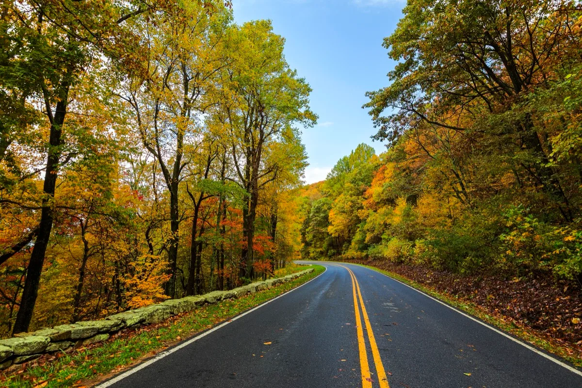
Stop 10
Shenandoah National Park & Skyline Drive, VA
South on I-81 — directly toward home
Skyline Drive is the finale this trip deserves. You've driven deserts and mountains and coasts and prairies, and now the Blue Ridge folds away from you in every direction, green or gold or silver depending on the season, and home is close. There are elk in the meadows and black bears in the woods and 75 places to pull off and let the Appalachians remind you where you come from.
Skyline Drive runs 105 miles along the crest of the Blue Ridge Mountains through Shenandoah National Park. Every one of its 75 overlooks gives a different view of the valley below and the mountains beyond. Dark Hollow Falls — a 70-foot waterfall reachable in 1.5 miles — is a perfect last hike. The Appalachians here are old and rounded and blue in the distance and they look like home even when they're not.
★ The moment
Pulling off at one of the 75 overlooks at the golden hour and watching the blue haze settle into the valley below while the mountains fold away in every direction. You've crossed the whole country. You're almost home. This view earns everything.
⚠ Classic mistake
Entering at the north end (Front Royal) and exiting at the south end (Waynesboro) without stopping at Mather Point equivalent here: Big Meadows. It's a vast open mountain meadow at 3,500 feet where elk graze at dusk. In summer and fall they are reliably present from the meadow edge.
📷 The photograph
Big Meadows overlook at dusk — the meadow in the foreground, the mountains layered blue and purple behind it, and if timing is right, elk silhouetted against the fading light.
⏱ How long do you need?
2 hours: drive the southern third of Skyline Drive with 3–4 overlooks. Half day: drive the full length at a relaxed pace. Full day: add Dark Hollow Falls hike and dusk at Big Meadows for elk.
💬 What to ask
Ask a ranger about the Appalachian Trail — it runs the length of Shenandoah and crosses Skyline Drive 28 times. Ask how many people attempt the full 2,190-mile trail each year, and how many finish. The numbers are humbling.
Skip it if
Skyline Drive is closed due to ice (uncommon but possible in winter).
Don’t skip it if
You want to end the outbound journey of your lives with something worthy of it. This is worthy.
Entry fee
$35/vehicle (7-day pass).
Gas
Luray and Front Royal at the north end; Waynesboro and Staunton at the south. Very limited inside the park.
Don't miss eating
Virginia apple pie from any roadside stand in the Shenandoah Valley — Virginia grows some of the finest apples in the country and the valley below the park is full of orchards. Buy a bag of apples too.
Website
nps.gov/shen
This season
Spring / Summer
May: dogwood and redbud bloom along the drive. June brings mountain laurel. Elk in Big Meadows are active at dawn and dusk.
Summer / Fall
October peak foliage on Skyline Drive is one of the great fall color experiences in the East. Overlooks are busy on weekends but the beauty is non-negotiable.
Fall / Winter
November: the leaf-off views are longer and more expansive. Many facilities close but the drive stays open.
Winter / Spring
March and April: the park wakes up fast. First wildflowers by late March. Quietly beautiful for the final push home.
Average weather, all twelve months
| Jan | Feb | Mar | Apr | May | Jun | Jul | Aug | Sep | Oct | Nov | Dec | |
|---|---|---|---|---|---|---|---|---|---|---|---|---|
| High | 38° | 42° | 52° | 63° | 72° | 79° | 83° | 82° | 76° | 65° | 54° | 42° |
| Low | 20° | 22° | 30° | 40° | 50° | 58° | 63° | 62° | 55° | 43° | 33° | 24° |
| Rain | 3.0" | 2.8" | 3.5" | 3.3" | 4.0" | 3.8" | 3.8" | 3.4" | 3.5" | 3.0" | 3.2" | 3.1" |
Other options nearby
Things to do
Shenandoah National Park
4.8★National Park
Blue Ridge park encompassing 200,000 acres of forest, trails, waterfalls & Skyline Drive vistas.
Luray Caverns
4.7★Tourist Attraction
Massive underground lair with 140-ft. natural columns, colorful stalactites & brick walkways.
Harry F. Byrd, Sr. Visitor Center
4.7★Visitor Center
Skyline Drive resource for info, maps, exhibits & ranger programs plus restrooms & first aid.
Dark Hollow Falls Trailhead
4.8★Hiking Area
Popular 1.4-mi. roundtrip downhill hike to scenic falls, past sitting rocks & mountain laurel.
Cooter's Place - Luray
4.6★Museum
Shopping & dining locale with a museum, shop & eatery dedicated to The Dukes of Hazzard TV series.
Food & drink
Early Mountain Vineyards
4.5★Vineyard
Cooter's Place - Luray
4.6★Museum
Shopping & dining locale with a museum, shop & eatery dedicated to The Dukes of Hazzard TV series.
Broad Porch Coffee and Cafe
4.8★Cafe
Southern Kitchen
4.4★American Restaurant
Old-school diner dishing up fried chicken & other Southern-style comfort meals, morning til night.
Chop House Bistro
4.7★Restaurant
Alaska or Bust · Made with love, for the adventure of a lifetime.