The Pacific Coast Highway through Big Sur is one of those drives that you have seen in car commercials your whole life, and it is better than the commercials. The Santa Lucia Mountains drop directly into the ocean with no beach between them. The scale of the cliffs, the color of the water, the fog coming in from the Pacific in the morning — it operates on a frequency that is hard to describe and impossible to forget.
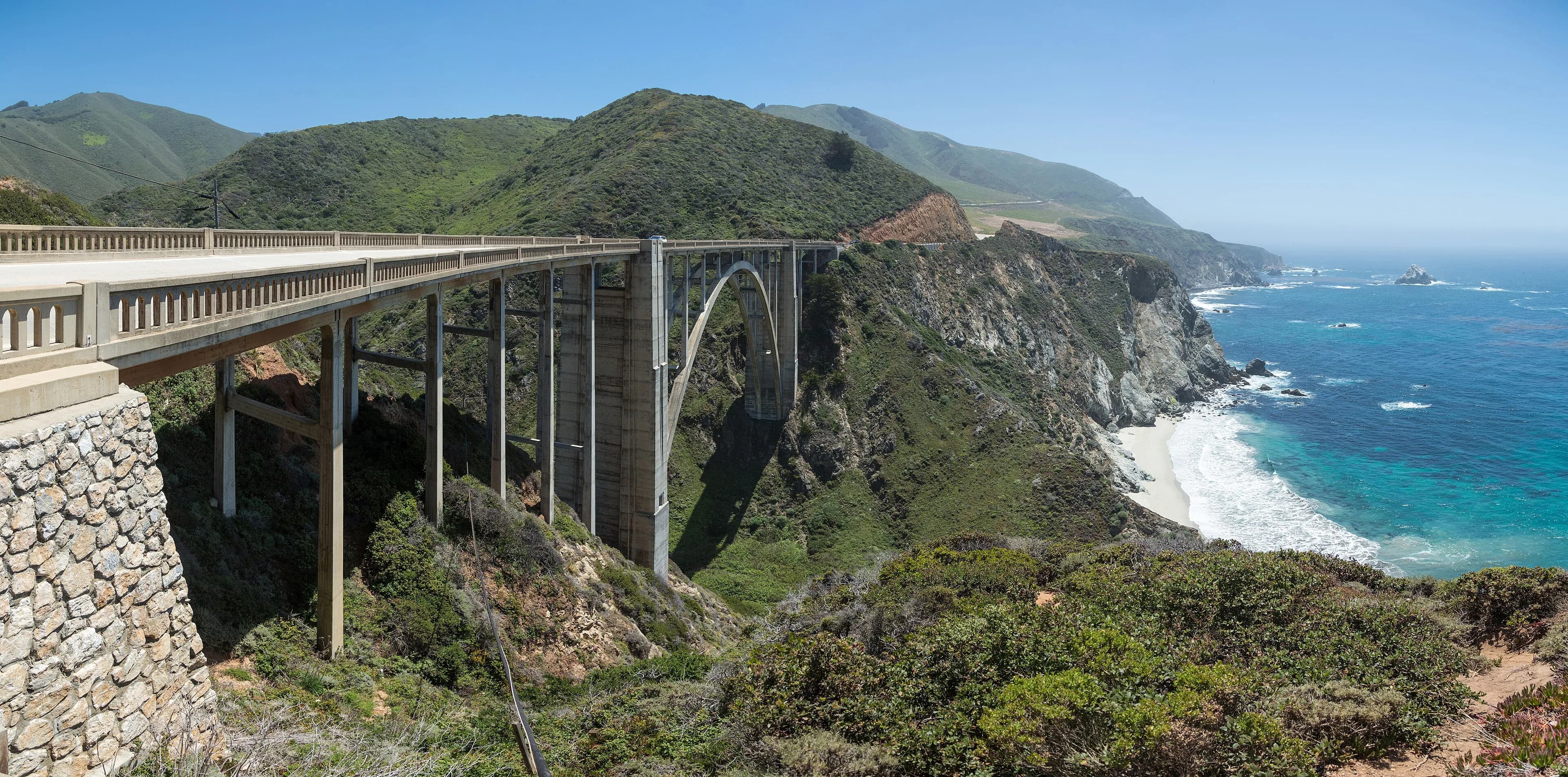
Highway 1 through Big Sur hugs 90 miles of coast where 4,000-foot cliffs meet the Pacific Ocean. Bixby Bridge spans a sea-carved canyon 260 feet above the ocean. McWay Falls drops 80 feet onto a private beach cove that no human can reach. Every single pullout on this road rewards stopping.
Make this stop yours
Skip it, leave a note, or swap in something else. Saved to your shared plan.
Add your own stops
Found another place worth a visit around Big Sur & Pacific Coast Highway, CA? Add it and it joins your trip and maps.
The moment
Pulling off at Bixby Bridge and walking to the overlook as the late afternoon fog starts rolling in from the Pacific below the bridge. The fog moves slowly. The bridge is very orange. The canyon below it is very deep. The ocean beyond is very blue. This is one of the great views in the United States.
The classic mistake
Running out of gas. This is not a metaphor. There is no gas for 90 miles between Carmel and San Simeon. Fill the tank completely in Carmel before heading south on Highway 1. This mistake has stranded many people.
The photograph
Bixby Bridge from the north overlook pullout, late afternoon — position the bridge in the lower third of the frame with the canyon below it and the ocean in the background. The fog in the canyon below the bridge is the bonus.
Skip it if
Highway 1 is closed due to slides or storm damage — check conditions at dot.ca.gov before committing to this route.
Don’t skip it if
You want to drive one of the most beautiful roads on Earth. This is it.
How long do you need?
Half day: drive Highway 1 with pullouts at Bixby Bridge and McWay Falls. Full day: add Point Lobos State Reserve north of Carmel (one of the most beautiful parks in California) and a long lunch at Nepenthe.
What to ask
At Nepenthe restaurant, ask your server about the cabin on the property that Orson Welles bought for Rita Hayworth as a honeymoon cottage. It's still there, now used as a wine bar above the main restaurant.
🌸 This season · Spring / Summer
May and June bring morning sea fog that burns off by noon — beautiful and atmospheric. Wildflowers on the coastal bluffs in April and May.
Entry fee
Julia Pfeiffer Burns State Park (McWay Falls): ~$10/vehicle. Highway 1 itself is free.
Gas
CRITICAL: Fill completely in Carmel before heading south. No gas for 90 miles.
Don't miss eating
The vegetable plate and fresh-baked bread at Nepenthe restaurant — perched 800 feet above the Pacific, serving food since 1949. Nepenthe has always done excellent vegetarian food alongside everything else. The view while eating it is the point regardless of what's on the plate.
Websitevisitcalifornia.com/region/big-sur
Average weather, all twelve months
| Jan | Feb | Mar | Apr | May | Jun | Jul | Aug | Sep | Oct | Nov | Dec | |
|---|---|---|---|---|---|---|---|---|---|---|---|---|
| High | 59° | 62° | 63° | 65° | 67° | 69° | 70° | 71° | 72° | 70° | 65° | 59° |
| Low | 43° | 45° | 46° | 48° | 51° | 54° | 55° | 56° | 55° | 52° | 47° | 43° |
| Rain/Snow | 4.8" | 4.0" | 3.5" | 1.5" | 0.5" | 0.1" | 0.0" | 0.1" | 0.4" | 1.5" | 3.0" | 4.0" |